IMAGES TAKEN NEAR TO
Falsgrave Road, SCARBOROUGH, YO12 5AT
Introduction
This page details the photographs taken nearby to Falsgrave Road, YO12 5AT by members of the Geograph project.
The Geograph project started in 2005 with the aim of publishing, organising and preserving representative images for every square kilometre of Great Britain, Ireland and the Isle of Man.

There are currently over 7.5m images from over14,400 individuals and you can help contribute to the project by visiting https://www.geograph.org.uk
Image Map
Images are licensed for reuse under creativecommons.org/licenses/by-sa/2.0
Notes
- Clicking on the map will re-center to the selected point.
- The higher the marker number, the further away the image location is from the centre of the postcode.
Image Listing (343 Images Found)
Images are licensed for reuse under creativecommons.org/licenses/by-sa/2.0
Image
Details
Distance
1

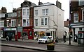
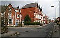
Falsgrave Road, Scarborough
Terraces of attractively bay-fronted houses on the north side of the road.
Image: © Paul Harrop
Taken: 10 Jun 2015
0.02 miles
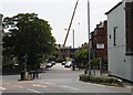
2

Falsgrave Road
This east north-easterly facing photograph was taken from the pedestrian reservation on Falsgrave Road between its junction with Image (ahead, left, by the no-entry sign) and Image (behind the viewpoint, right).
On the far right of the picture there is a low white and red building, the apex of the roof of which faces the road. By the side of this building is the entrance to an alleyway, which, in the 1950’s and 1960’s was known locally as Image To see a closer view of the entrance to the alleyway, taken from a few metres ahead of the viewpoint, click here Image
For another photograph of Falsgrave Road, taken from approximately the same viewpoint but facing the opposite direction, click here Image
Road name information from OS Maps.
Image: © Alan Walker
Taken: 9 Apr 2008
0.02 miles
3
Falsgrave Road
Image: © Alan Walker
Taken: 9 Apr 2008
0.04 miles
4
Rebuilding on Belgrave Crescent
Viewed from West Parade near its junction with Westborough/Falsgrave Road; Belgrave Crescent is seen with building work ongoing at the site shown in Image
Image: © Christopher Hall
Taken: 2 Jul 2014
0.04 miles
6
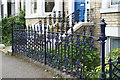
Cast iron railings Belgrave Crescent
A rare survival of the original cast iron frontage railings (known as area railings) and flanking the entrance steps at a terrace house on the south west side of Belgrave Crescent. The railings are contemporary with the houses ie circa 1870. a nice contrast between the robustness of the two newels and the delicacy of the balustrades.
Image: © Christopher Hall
Taken: 26 Jun 2008
0.04 miles

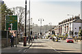
8
Londesborough Road
This north-easterly facing photograph is of Londesborough Road near its junction with Image (left).
Some 50metres ahead, on the left beyond the tall, three house terrace, is the junction of Londesborough Road with All Saints’ Road.
For another photograph of Londesborough Road, taken from the same viewpoint but facing the opposite (south-westerly) direction, click here Image
Road name information from OS Maps.
Image: © Alan Walker
Taken: 9 Apr 2008
0.05 miles
9
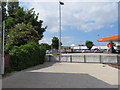
Approaching Sainsbury's on foot from Falsgrave Road
This is the pedestrian access to Sainsbury's new store from Falsgrave Road. The fence seemingly blocking the way is misleading as the path turns left at the end of the wall beyond the foliage. The fence separates pedestrians from the traffic entering the car park.
Image: © John S Turner
Taken: 30 Jun 2014
0.05 miles
10
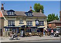
The Ship Inn, Scarborough
Pub on Falsgrave Road.
Image: © Paul Harrop
Taken: 10 Jun 2015
0.06 miles