IMAGES TAKEN NEAR TO
Estill Close, SCARBOROUGH, YO11 3TA
Introduction
This page details the photographs taken nearby to Estill Close, YO11 3TA by members of the Geograph project.
The Geograph project started in 2005 with the aim of publishing, organising and preserving representative images for every square kilometre of Great Britain, Ireland and the Isle of Man.

There are currently over 7.5m images from over14,400 individuals and you can help contribute to the project by visiting https://www.geograph.org.uk
Image Map
Images are licensed for reuse under creativecommons.org/licenses/by-sa/2.0
Notes
- Clicking on the map will re-center to the selected point.
- The higher the marker number, the further away the image location is from the centre of the postcode.
Image Listing (72 Images Found)
Images are licensed for reuse under creativecommons.org/licenses/by-sa/2.0
Image
Details
Distance
1

Cayton Bay from the air
The McCains Foods factory https://www.mccain.co.uk/ is just visible between the clouds at the bottom of the photo. Osgodby Point is prominent in the background.
Image: © Thomas Nugent
Taken: 18 Aug 2017
0.07 miles
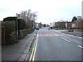
2
North Lane, Cayton
Looking north from the B1261.
Image: © JThomas
Taken: 23 Jan 2016
0.10 miles
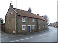
3

North Lane, Cayton
Looking west from Church Lane.
Image: © JThomas
Taken: 13 Feb 2016
0.10 miles

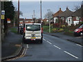
5
Bus stop on the B1261, Cayton
Looking west.
Image: © JThomas
Taken: 23 Jan 2016
0.10 miles

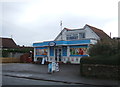
9

Cayton, Methodist church
The benchmark is cut into the stone course, and is partially hidden by the shrubbery.
Image: © Mel Towler
Taken: 23 Feb 2022
0.12 miles
