IMAGES TAKEN NEAR TO
Carr House Lane, SCARBOROUGH, YO11 3ST
Introduction
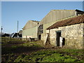
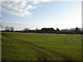
This page details the photographs taken nearby to Carr House Lane, YO11 3ST by members of the Geograph project.
The Geograph project started in 2005 with the aim of publishing, organising and preserving representative images for every square kilometre of Great Britain, Ireland and the Isle of Man.

There are currently over 7.5m images from over14,400 individuals and you can help contribute to the project by visiting https://www.geograph.org.uk
Image Map
Images are licensed for reuse under creativecommons.org/licenses/by-sa/2.0
Notes
- Clicking on the map will re-center to the selected point.
- The higher the marker number, the further away the image location is from the centre of the postcode.
Image Listing (10 Images Found)
Images are licensed for reuse under creativecommons.org/licenses/by-sa/2.0
Image
Details
Distance
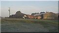
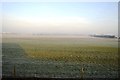
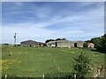
5
Field at Carr House Farm
Train from Hull to Scarborough can be seen on railway mid distance
Image: © Martin Dawes
Taken: 21 Jan 2009
0.08 miles
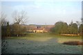
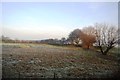
7
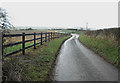
Winding to The Carrs and The Wolds
The flat land between Filey to the east and Pickering to the West (once the huge Lake Pickering) has many place names reflecting its wetland history, generally either 'Carr' or 'Ings'. The northern edge of the Wolds can be seen in the distance
Image: © Chris Yeates
Taken: 26 Dec 2005
0.12 miles