IMAGES TAKEN NEAR TO
Greenfield Road, SCARBOROUGH, YO11 2LP
Introduction
This page details the photographs taken nearby to Greenfield Road, YO11 2LP by members of the Geograph project.
The Geograph project started in 2005 with the aim of publishing, organising and preserving representative images for every square kilometre of Great Britain, Ireland and the Isle of Man.

There are currently over 7.5m images from over14,400 individuals and you can help contribute to the project by visiting https://www.geograph.org.uk
Image Map
Images are licensed for reuse under creativecommons.org/licenses/by-sa/2.0
Notes
- Clicking on the map will re-center to the selected point.
- The higher the marker number, the further away the image location is from the centre of the postcode.
Image Listing (290 Images Found)
Images are licensed for reuse under creativecommons.org/licenses/by-sa/2.0
Image
Details
Distance
1

Grosvenor Crescent central garden
Grosvenor Crescent dates from about 1867 to 1872. It was also part of the Weaponness Estate laid out by Joseph Paxton . This central garden would originally have been for the private use of the residents but is now a small public park.
Image: © Christopher Hall
Taken: 1 Feb 2014
0.04 miles
2

Grosvenor Crescent
Grosvenor Crescent is contemporary with Albion Crescent, see Image i.e. built between about 1867 and 1872. It is also part of the Weaponness Estate laid out by Joseph Paxton and again the houses are built in white silica brick. In this case the central gardens are now a small public park but in the 19th century they would have been private gardens for the houses, surrounded by iron railings, not a hedge.
Image: © Christopher Hall
Taken: 1 Feb 2014
0.04 miles
3

Ayckbourn Chapters
Three blocks of flats on Royal Avenue on the site of the former St Martin's School demolished in 1988 and shown inImage The entrance feature is the former entrance to the school; it is just seen in the extreme left of Image but as part of the redevelopment for the flats it was taken down brick by brick and relocated a few metres to the north in order to allow the formation of the drive.
The flats are named after Sir Alan Ayckbourn, a Scarborough resident.
Image: © Christopher Hall
Taken: 19 Jan 2015
0.04 miles
4
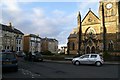
Albion Crescent and St Andrews Church
Albion Crescent was developed between about 1867 and 1872 and is one of several crescents on Scarborough's south cliff. It is probably part of the Weaponness Estate laid out for development by Joseph Paxton. The frontages of the houses are built in white silica brick. In the case of Albion crescent, what would be central gardens is occupied by St Andrews Church.
Image: © Christopher Hall
Taken: 1 Feb 2014
0.04 miles
5
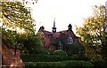
Former St Martins School
This is the former St Martin's C of E junior school on Royal Avenue. The school was opened in 1898 and designed by the Scarborough Architects Messrs Tugwell (Frank & Sydney Tugwell) in the Arts & Crafts style of which Frank Tugwell was a fine regional exponent.
The photograph was taken in October 1988 just before the demolition of the school.
Image: © Christopher Hall
Taken: Unknown
0.05 miles
7
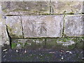
Bench mark outside #10 Royal Avenue
This bench mark is on the garden wall of #10 Royal Avenue. See also Image
Image: © John S Turner
Taken: 27 Jan 2011
0.05 miles
8
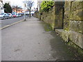
Royal Avenue and a bench mark
The bench mark on the right is on the garden wall of #10 Royal Avenue Image Ramshill Road crosses the end of the avenue.
Image: © John S Turner
Taken: 27 Jan 2011
0.05 miles
9
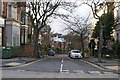
Royal Avenue
Royal Avenue is a tree lined street which runs down from Ramshill Road (junction it the foreground) to Valley Road. The terrace of white brick houses on the right is circa 1879-89 whilst the more eclectic buildings on the left are circa 1891-1901.
Image: © Christopher Hall
Taken: 1 Feb 2014
0.05 miles
10
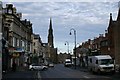
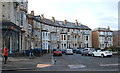
Ramshill Road
This view north along Ramshill Road is terminated by St Andrews United Reformed Church. This massive church in the gothic style built between 1864 and 1868 is known as 'The Cathedral of Non-conformism'.
Ramshill Road was originally the road to Bridlington but from the mid 19th century it became a shopping and service street to meet the needs of the growing population on South Cliff. On the left typical 19th century shops and on the near right the former St Martin's Grammar School
Image: © Christopher Hall
Taken: 27 Nov 2013
0.06 miles