IMAGES TAKEN NEAR TO
Overton Terrace, SCARBOROUGH, YO11 1PW
Introduction
This page details the photographs taken nearby to Overton Terrace, YO11 1PW by members of the Geograph project.
The Geograph project started in 2005 with the aim of publishing, organising and preserving representative images for every square kilometre of Great Britain, Ireland and the Isle of Man.

There are currently over 7.5m images from over14,400 individuals and you can help contribute to the project by visiting https://www.geograph.org.uk
Image Map
Images are licensed for reuse under creativecommons.org/licenses/by-sa/2.0
Notes
- Clicking on the map will re-center to the selected point.
- The higher the marker number, the further away the image location is from the centre of the postcode.
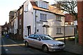
Image Listing (1460 Images Found)
Images are licensed for reuse under creativecommons.org/licenses/by-sa/2.0
Image
Details
Distance
1

Derelict building in Quay Street, Scarborough
Image: © Nick Mutton 01329 000000
Taken: 2 Jul 2010
0.02 miles
2

Derelict building in Quay Street, Scarborough
Image: © Nick Mutton 01329 000000
Taken: 2 Jul 2010
0.02 miles
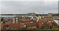
3
Burr Bank, Scarborough
A short street running along the hillside above the harbour. Bottom left, you can just make out part of the name of a path running down towards the harbour - [Dog?] and Duck Lane.
Image: © Stephen Craven
Taken: 26 Mar 2017
0.02 miles
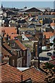
4

Path in Scarborough
A path on a hillside in Scarborough, on the North Yorkshire coast.
Image: © Malc McDonald
Taken: 30 Apr 2021
0.03 miles
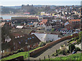
5
Scarborough rooftops
Part of the Old Town, seen from the path which leads down from the castle walls to the harbour area.
Image: © Paul Harrop
Taken: 10 Jun 2015
0.03 miles
6
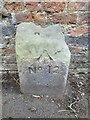
Old Boundary Marker on Burr Bank, Scarborough
War Department Boundary Marker against a brick wall on the south side of Burr Bank footpath, immediately to the east of the top of the steps in Dog and Duck Lane. Inscribed W D / (arrow) / 12.
Milestone Society National ID: YN_WDSCAR12em
Image: © M Hatton
Taken: Unknown
0.03 miles
8

Car park, Quay Street
Viewed from Long Greece Steps, this car park is on the site of Scarborough's first gas works. The gas works were started in the 1830s but in 1875 moved to a site near Seamer Road alongside the railway line. In the 1830s coal would have come in by sea. The gas works buildings then had various uses including an ice house for the fishing trade but were finally demolished in the early 1970s and this car park created.
Image: © Christopher Hall
Taken: 23 Jun 2014
0.04 miles
9
Quay Street and Porritts Lane
Looking along Quay Street past where Porritts Lane comes in from the right; this is one of several lanes that connect Quay Street to Sandside. Quay Street is now well back from the sea because the quay alignment has moved since medieval times.
Image: © Christopher Hall
Taken: 4 Dec 2013
0.04 miles
10

Wesley House
An attractive Georgian building [only the attic windows look out of place] on Castlegate, with a view along Princess Street. One of several Georgian properties in the old part of the town.
Image: © Gordon Hatton
Taken: 10 Jun 2009
0.04 miles