IMAGES TAKEN NEAR TO
Maria's Court, SCARBOROUGH, YO11 1HH

Introduction

This page details the photographs taken nearby to Maria's Court, YO11 1HH by members of the Geograph project.

The Geograph project started in 2005 with the aim of publishing, organising and preserving representative images for every square kilometre of Great Britain, Ireland and the Isle of Man.

There are currently over 7.5m images from over14,400 individuals and you can help contribute to the project by visiting https://www.geograph.org.uk

Image Map


Images are licensed for reuse under creativecommons.org/licenses/by-sa/2.0
Notes
  • Clicking on the map will re-center to the selected point.
  • The higher the marker number, the further away the image location is from the centre of the postcode.

Image Listing (536 Images Found)

Images are licensed for reuse under creativecommons.org/licenses/by-sa/2.0
  • ...
Image
Details
Distance
1
Scarborough: up Queen Street
Sunlight and shadow on an August morning.
Image: © John Sutton Taken: 24 Aug 2016
0.01 miles
2
St Mary's Lodge
Image: © SMJ Taken: 31 Aug 2011
0.02 miles
3
The Scarborough - Auborough Street
Image: © Betty Longbottom Taken: 6 Sep 2010
0.02 miles
4
Site of the Castle Road Gaol
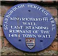
Looking across the junction of St Thomas Street with Castle Road towards the site of the old Castle Road Gaol. The gaol was built around 1840 after the one in Newborough Bar became unfit. However, the Castle Road Gaol was also easy to break out of and was itself closed in 1866. The prisoners were then transferred to the Dean Road Gaol, which still stands on part of the council depot site. The old gaol building, which once stood on the site shown here, served as a police station and court house until 1971 when it was demolished following the creation of new police and court buildings in Northway. There is an interesting website about the Scarborough gaols: http://www.scarboroughjail.co.uk/index.html The section of stone wall at the back of the car park carries a blue plaque claiming that it is a remnant of the old town wall of 1484 - the time of Richard III.
Image: © John S Turner Taken: 12 Jul 2010
0.03 miles
5
Fragment of town wall
This wall between the North Terrace car park and the YMCA contains a small fragment of the Newborough defences. The Newborough defences were improved by Richard III by replacing what was probably a palisade by a stone wall. Archaeological excavations by the local archaeological society have shown that the stone work here is part of that wall; the only visibly surviving fragment.
Image: © Christopher Hall Taken: 23 Nov 2013
0.03 miles
6
Castle Road junction with Queen Street
Scarborough suburbs.
Image: © Pauline E Taken: 10 Feb 2014
0.03 miles
7
Plaque marking the presence of a fragment of town wall
This plaque is on the wall which separates North Terrace car park from the grounds of the YMCA. The Newborough defences crossed here and a short fragment of stone wall has been shown to be part of the wall built by Richard III
Image: © Christopher Hall Taken: 23 Nov 2013
0.03 miles
8
Maria's Court - Queen Street
Image: © Betty Longbottom Taken: 6 Sep 2010
0.03 miles
9
Queen Street, Scarborough
A road heading towards South Bay and the town centre from Castle Road.
Image: © Andrew Smith Taken: 26 Apr 2008
0.04 miles
10
Roundabout for the Indigo Alley
Looking across the junction of North Marine Drive and Castle Rd the pub on the left is Scarborough's famous Indigo Alley https://www.facebook.com/indigoalley it seems it went through a bad patch after the retirement of mine hosts but it seems to be thriving again now.
Image: © Glyn Baker Taken: 27 Apr 2014
0.05 miles
  • ...