IMAGES TAKEN NEAR TO
Hospital Fields Road, YORK, YO10 4FF
Introduction
This page details the photographs taken nearby to Hospital Fields Road, YO10 4FF by members of the Geograph project.
The Geograph project started in 2005 with the aim of publishing, organising and preserving representative images for every square kilometre of Great Britain, Ireland and the Isle of Man.

There are currently over 7.5m images from over14,400 individuals and you can help contribute to the project by visiting https://www.geograph.org.uk
Image Map
Images are licensed for reuse under creativecommons.org/licenses/by-sa/2.0
Notes
- Clicking on the map will re-center to the selected point.
- The higher the marker number, the further away the image location is from the centre of the postcode.
Image Listing (163 Images Found)
Images are licensed for reuse under creativecommons.org/licenses/by-sa/2.0
Image
Details
Distance
1
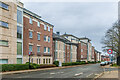
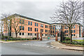
Fulford Place
Development of apartment blocks on Hospital Fields Road completed in 2003, with Heslington House nearest.
Image: © Ian Capper
Taken: 4 Feb 2023
0.03 miles
2
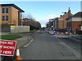
Roadworks on Hospital Fields Road
Temporary traffic lights to allow installation of a new high voltage underground cable.
Image: © DS Pugh
Taken: 16 Feb 2014
0.03 miles
3
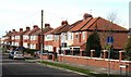
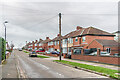
Maple Grove, York
Suburban semis of the 1930's just off Fulford Road.
Image: © Gordon Hatton
Taken: 8 Feb 2009
0.04 miles
4
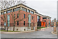
Fulford Moor House
Late 20th Century office block on the site of a former military hospital (later part and then fully civilian) which closed in 1976 and was demolished soon after. The occupant is the payment services company TSYS.
Image: © Ian Capper
Taken: 4 Feb 2023
0.04 miles
5
Alexander House
Early 21st Century office block in Hospital Fields Road built on part of the site of a former military hospital (later part and then fully civilian) which closed in 1976 and was demolished soon after. The occupant is the automobile software company ETAS.
Image: © Ian Capper
Taken: 4 Feb 2023
0.04 miles
6
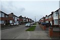
Maple Grove
Cul-de-sac off Fulford Road, with houses in the easternmost section (including those seen here) marked on the 1941 25 inch map.
Image: © Ian Capper
Taken: 4 Feb 2023
0.05 miles
7
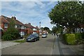
Looking along Maple Grove
Leading down to the river.
Image: © DS Pugh
Taken: 22 Feb 2020
0.05 miles
9

Hospital Fields
One of two terraces of housing off what is now Hospital Fields Road, built in 1924 as married quarters for staff at the adjacent military hospital, marked as such on the 1936 25 inch map.
Image: © Ian Capper
Taken: 4 Feb 2023
0.05 miles
10
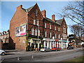
Row of shops on Fulford Road
From left to right are Beilby's newsagent & tobacconist, a Sainsbury's local shop and a branch of Lloyds pharmacy. The terrace dates from the 1870's and is without any charm or grace. Compare with the much more elegant villas of 30 years before further along the same road.
Image: © Gordon Hatton
Taken: 8 Feb 2009
0.06 miles