IMAGES TAKEN NEAR TO
Fulford Road, YORK, YO10 4EA
Introduction
This page details the photographs taken nearby to Fulford Road, YO10 4EA by members of the Geograph project.
The Geograph project started in 2005 with the aim of publishing, organising and preserving representative images for every square kilometre of Great Britain, Ireland and the Isle of Man.

There are currently over 7.5m images from over14,400 individuals and you can help contribute to the project by visiting https://www.geograph.org.uk
Image Map
Images are licensed for reuse under creativecommons.org/licenses/by-sa/2.0
Notes
- Clicking on the map will re-center to the selected point.
- The higher the marker number, the further away the image location is from the centre of the postcode.
Image Listing (180 Images Found)
Images are licensed for reuse under creativecommons.org/licenses/by-sa/2.0
Image
Details
Distance
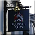
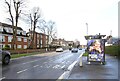
1
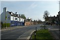
Fulford Arms
Looking along Fulford Road from the end of Alma Terrace.
Image: © DS Pugh
Taken: 10 Apr 2020
0.00 miles
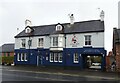
2
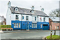
Fulford Arms
Pub on Fulford Road opened in 1801 as the Barrack Tavern, named after the adjacent cavalry barracks which had been constructed in 1795. It was renamed in the 1970s.
Image: © Ian Capper
Taken: 4 Feb 2023
0.02 miles
5
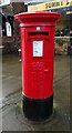
Elizabeth II postbox on Fulford Road
Image: © JThomas
Taken: 23 Feb 2024
0.02 miles
6
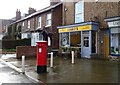
Sunny's Café on Fulford Road
Showing position of Postbox No. YO10 101.
See Image] for postbox.
Image: © JThomas
Taken: 23 Feb 2024
0.02 miles
7
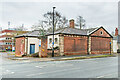
Former guardhouse, Cavalry Barracks
One of a pair of former guardhouses either side of the (now blocked up) entrance to the Cavalry Barracks off Fulford Road. Most of the barrack buildings were built in 1795, and were demolished in the 1970s with the Fulford Police Station being built on part of the site (in the left background in this photo). The guardhouses date from the late 19th Century.
Image: © Ian Capper
Taken: 4 Feb 2023
0.03 miles
8
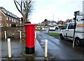
Fulford Road (A19)
Showing position of Postbox No. YO10 101.
See Image] for postbox.
Image: © JThomas
Taken: 23 Feb 2024
0.03 miles
10
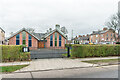
Christian Science Church
Christian Science Church on the corner of Kilburn Road and Fulford Road, built in 2012 replacing a previous church building dating from the 1920s.
Image: © Ian Capper
Taken: 4 Feb 2023
0.03 miles