IMAGES TAKEN NEAR TO
Kilburn Road, YORK, YO10 4DE
Introduction
This page details the photographs taken nearby to Kilburn Road, YO10 4DE by members of the Geograph project.
The Geograph project started in 2005 with the aim of publishing, organising and preserving representative images for every square kilometre of Great Britain, Ireland and the Isle of Man.

There are currently over 7.5m images from over14,400 individuals and you can help contribute to the project by visiting https://www.geograph.org.uk
Image Map (Loading...)


Getting Data...Please wait
Leaflet Map data © OpenStreetMap
Images are licensed for reuse under creativecommons.org/licenses/by-sa/2.0
Notes
- Clicking on the map will re-center to the selected point.
- The higher the marker number, the further away the image location is from the centre of the postcode.
Image Listing (157 Images Found)
Images are licensed for reuse under creativecommons.org/licenses/by-sa/2.0
Image
Details
Distance
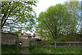
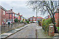
1
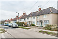
Kilburn Road
Cul-de-sac off Fulford Road started in the c.1920s (such as nearest house) and extended in the c.1930s (such as those beyond), as evidenced by the 1931 and 1940 25 inch maps respectively. The road was named after a house called Kilburn House which stood to the north of it which was demolished c.1920. This had originally been called Fulford Lodge but was renamed in the 1870s by Alderman Joseph Agar, a leather merchant and three times Lord Mayor of York in the 1880s, who was born in Kilburn in North Yorkshire and who bought the house in 1875.
Image: © Ian Capper
Taken: 4 Feb 2023
0.02 miles
2
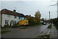
Kilburn Road
Looking along Kilburn Road from the junction with Edgware Road.
Image: © DS Pugh
Taken: 29 Oct 2022
0.05 miles
3
Edgware Road
Looking along Edgware Road off Kilburn Road.
Image: © DS Pugh
Taken: 2 Nov 2020
0.05 miles
4
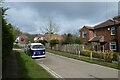
Edgware Road
Looking along Edgware Road from Kilburn Road.
Image: © DS Pugh
Taken: 14 Mar 2021
0.06 miles
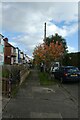
5
Path into the allotments
Looking into the allotments from Walmgate Stray.
Image: © DS Pugh
Taken: 23 Apr 2020
0.09 miles
6
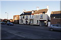
Fulford Arms Public House on Fulford Road York
Image: © Michael Jagger
Taken: 7 Mar 2010
0.09 miles
8
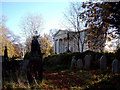
York Cemetery
"Opened in 1837, York Cemetery is a twenty four acre green site within suburban York. Now owned by The York Cemetery Trust (Registered Charity Number 1075408), the site is managed using an ecological land management plan for the purposes of conservation, restoration and education. The Trust is helped in this work by The Friends of York Cemetery (Registered Charity Number 701091)"
Taken from home page of http://www.yorkcemetery.co.uk/
Image: © Alison Stamp
Taken: 17 Nov 2005
0.10 miles
9

Low Moor Allotments
Looking along the path through the allotments towards Kilburn Road.
Image: © DS Pugh
Taken: 15 Jan 2022
0.10 miles
10
Maida Grove
Cul-de-sac off Fulford Road built in the c.1930s, first shown on the 1940 25 inch map on the site of a house named Kilburn House. which was demolished c.1920. This had originally been called Fulford Lodge but was renamed in the 1870s by Alderman Joseph Agar, a leather merchant and three times Lord Mayor of York in the 1880s, who was born in Kilburn in North Yorkshire and who bought the house in 1875. However it seems that the developers of the area assumed it was Kilburn in north west London, and so named the streets they built after other such places - e.g. Maida (Vale).
Image: © Ian Capper
Taken: 4 Feb 2023
0.10 miles