IMAGES TAKEN NEAR TO
Lesscroft Close, WOLVERHAMPTON, WV9 5LJ
Introduction
This page details the photographs taken nearby to Lesscroft Close, WV9 5LJ by members of the Geograph project.
The Geograph project started in 2005 with the aim of publishing, organising and preserving representative images for every square kilometre of Great Britain, Ireland and the Isle of Man.

There are currently over 7.5m images from over14,400 individuals and you can help contribute to the project by visiting https://www.geograph.org.uk
Image Map
Images are licensed for reuse under creativecommons.org/licenses/by-sa/2.0
Notes
- Clicking on the map will re-center to the selected point.
- The higher the marker number, the further away the image location is from the centre of the postcode.
Image Listing (82 Images Found)
Images are licensed for reuse under creativecommons.org/licenses/by-sa/2.0
Image
Details
Distance
1
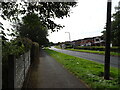
The Droveway
The view at Pendeford, Wolverhampton.
Image: © Gordon Griffiths
Taken: 28 Sep 2020
0.07 miles
2
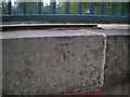
OS benchmark - Pendeford, The Droveway
An OS cutmark, dating from 1982, cut onto the parapet wall of a bridge carrying The Droveway over a pedestrian subway; it was originally levelled at 103.993m above Ordnance Datum Newlyn.
Image: © Richard Law
Taken: 18 Oct 2016
0.09 miles
3
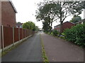
Ryhope Walk
The view in Pendeford, Wolverhampton.
Image: © Gordon Griffiths
Taken: 28 Sep 2020
0.09 miles
4
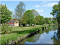
Canal and parkland near Pendeford in Wolverhampton
Looking north towards Marsh Lane Bridge, this shows the Staffordshire and Worcestershire Canal. Open parkland and housing estates to the left were developed on the former Wolverhampton Municipal Airport. Sustrans Route 81 passes along the towpath.
Image: © Roger Kidd
Taken: 14 May 2016
0.11 miles
5
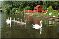
Swans on Staffs & Worcs Canal
A swan family glides serenely past suburban gardens in the Fordhouses district of Wolverhampton.
Image: © Stephen McKay
Taken: 2 Aug 2007
0.12 miles
6

Staffordshire and Worcestershire Canal near Pendeford, Wolverhampton
Looking north-east towards Marsh Lane Bridge, No 67. Housing off to the left is in Waterside Way, Clewley Drive and Wragby Close.
Image: © Roger Kidd
Taken: 19 Apr 2013
0.12 miles
7

Staffordshire and Worcestershire Canal near Pendeford, Wolverhampton
Looking north-east towards Marsh Lane Bridge, No 67.
Image: © Roger Kidd
Taken: 19 Apr 2013
0.12 miles
8
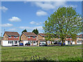
Houses in Pendeford in Wolverhampton
Looking north-west from the canal, open parkland and housing estates at Pendeford were developed on the former Wolverhampton Municipal Airport.
Image: © Roger Kidd
Taken: 14 May 2016
0.12 miles
9
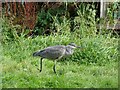
Heron walk
The view by the Staffordshire and Worcestershire Canal near Marsh lane Bridge at Pendeford.
Image: © Gordon Griffiths
Taken: 28 Sep 2020
0.12 miles
10

Staffordshire and Worcestershire Canal near Pendeford, Wolverhampton
Looking north-east towards Marsh Lane Bridge, No 67.
Image: © Roger Kidd
Taken: 19 Apr 2013
0.12 miles