IMAGES TAKEN NEAR TO
Innovation Drive, WOLVERHAMPTON, WV9 5GA
Introduction
This page details the photographs taken nearby to Innovation Drive, WV9 5GA by members of the Geograph project.
The Geograph project started in 2005 with the aim of publishing, organising and preserving representative images for every square kilometre of Great Britain, Ireland and the Isle of Man.

There are currently over 7.5m images from over14,400 individuals and you can help contribute to the project by visiting https://www.geograph.org.uk
Image Map
Images are licensed for reuse under creativecommons.org/licenses/by-sa/2.0
Notes
- Clicking on the map will re-center to the selected point.
- The higher the marker number, the further away the image location is from the centre of the postcode.
Image Listing (8 Images Found)
Images are licensed for reuse under creativecommons.org/licenses/by-sa/2.0
Image
Details
Distance
1
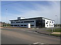
Eurofins laboratories
One of the first tenants along with MOOG on the new i54 development. The major tenant on the site will be Jaguar Land Rover with their new engine plant.
Image: © John M
Taken: 20 Oct 2012
0.12 miles
2
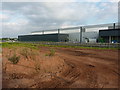
Jaguar Land Rover Engine Plant - i54 site
The i54 site has finally taken off with the decision to build an engine factory for JLR with access onto the adjacent M54 motorway.
Image: © John M
Taken: 20 Oct 2012
0.12 miles
3
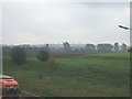
i54 Development near Fordhouses
The ground remediation works for this major development adjacent to the M54 have just commenced. Works will include a new motorway interchange.The high ground on the horizon is Bushbury Hill.
Image: © John M
Taken: 14 Oct 2006
0.20 miles
4
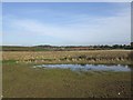
Balancing pond at i54 development
The site has been transformed by the preparation works.
Image: © John M
Taken: 12 Jan 2008
0.22 miles
5
Jaguar/LandRover engine plant at Pendeford
The factory is more or less complete, externally at any rate; there is still quite a bit of work underway to make a new motorway access for it.
Image: © Richard Law
Taken: 16 Jun 2014
0.23 miles
6
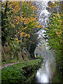
Autumn in Marsh Lane Narrows, Wolverhampton
Looking north-north-east towards Penkridge, this is the Staffordshire and Worcestershire Canal at the northern end of Marsh Lane Narrows, in which narrowboats cannot pass each other except at two small tight passing places.
This was a very dull damp day, which seemed to emphasise the autumn colours.
Image: © Roger Kidd
Taken: 24 Oct 2012
0.24 miles
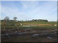
7
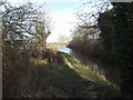
North of the Narrows
The Staffordshire and Worcestershire Canal returns to normal width.
Image: © John M
Taken: 12 Jan 2008
0.24 miles
8
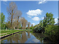
Canal near Fordhouses in Wolverhampton
This is the Staffordshire and Worcestershire Canal, looking north-north-east towards Coven and Penkridge. Sustrans Route 81 passes along the towpath. https://www.sustrans.org.uk/find-a-route-on-the-national-cycle-network/route-81/
Image: © Roger Kidd
Taken: 14 May 2016
0.25 miles