IMAGES TAKEN NEAR TO
Mount Pleasant, Brewood Road, WOLVERHAMPTON, WV9 5BN
Introduction
This page details the photographs taken nearby to Mount Pleasant, Brewood Road, WV9 5BN by members of the Geograph project.
The Geograph project started in 2005 with the aim of publishing, organising and preserving representative images for every square kilometre of Great Britain, Ireland and the Isle of Man.

There are currently over 7.5m images from over14,400 individuals and you can help contribute to the project by visiting https://www.geograph.org.uk
Image Map
Images are licensed for reuse under creativecommons.org/licenses/by-sa/2.0
Notes
- Clicking on the map will re-center to the selected point.
- The higher the marker number, the further away the image location is from the centre of the postcode.
Image Listing (28 Images Found)
Images are licensed for reuse under creativecommons.org/licenses/by-sa/2.0
Image
Details
Distance
4
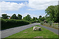
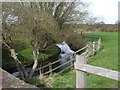
Brewood Road north-west of Coven in Staffordshire
Looking north-west towards Brewood.
The boulder informs travellers from Brewood that they are entering Coven. Ahead is Jackson's Bridge crossing the River Penk.
Image: © Roger Kidd
Taken: 14 Jul 2021
0.08 miles
5
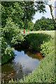
River Penk north-west of Coven in Staffordshire
Looking north-east downstream from Jackson's Bridge, Brewood Road. The river passes through a small well kept park here by Brewood Road.
Image: © Roger Kidd
Taken: 14 Jul 2021
0.09 miles
6
River Penk north-west of Coven in Staffordshire
Looking north-east downstream from Jackson's Bridge, Brewood Road. The river passes through a small well kept park here by Brewood Road.
Image: © Roger Kidd
Taken: 14 Jul 2021
0.09 miles
8
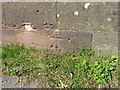
OS benchmark - Coven, Jackson's Bridge
An OS cutmark low on the NE parapet of Jackson's Bridge; originally levelled at 93.872m above Ordnance Datum newlyn.
Image: © Richard Law
Taken: 16 Jun 2014
0.09 miles
9
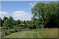
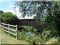
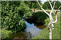
Park by Jackson's Bridge near Coven, Staffordshire
Jackson's Bridge carries Brewood Road across the River Penk by this attractively maintained public park at Lower Green Coven. It was originally called King's Bridge, until a man called Jackson hung himself from it. It is Grade II listed.
The grass has just been cut, leaving selected areas to nature, probably to be mowed in the autumn.
Image: © Roger Kidd
Taken: 14 Jul 2021
0.09 miles
10
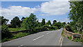
Brewood Road north-west of Coven in Staffordshire
Looking north-west towards Brewood at Jackson's Bridge (formerly King's Bridge), crossing the River Penk.
Apparently the bridge is named after a man named Jackson who hung himself beneath it.
Image: © Roger Kidd
Taken: 14 Jul 2021
0.09 miles