IMAGES TAKEN NEAR TO
Pendeford Hall Lane, WOLVERHAMPTON, WV9 5BD
Introduction
This page details the photographs taken nearby to Pendeford Hall Lane, WV9 5BD by members of the Geograph project.
The Geograph project started in 2005 with the aim of publishing, organising and preserving representative images for every square kilometre of Great Britain, Ireland and the Isle of Man.

There are currently over 7.5m images from over14,400 individuals and you can help contribute to the project by visiting https://www.geograph.org.uk
Image Map
Images are licensed for reuse under creativecommons.org/licenses/by-sa/2.0
Notes
- Clicking on the map will re-center to the selected point.
- The higher the marker number, the further away the image location is from the centre of the postcode.
Image Listing (57 Images Found)
Images are licensed for reuse under creativecommons.org/licenses/by-sa/2.0
Image
Details
Distance
1
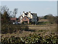
Upper Hattons Farm
A large extension has been built on this side of the farmhouse in the last few years Image]
Image: © Richard Law
Taken: 6 Apr 2013
0.01 miles
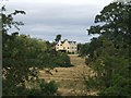
3
Upper Hattons
Taken from the stile that begins the footpath from Pendeford Hall Lane towards Upper Hattons.
Image: © Derek Harper
Taken: 18 Jul 2006
0.08 miles
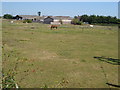
4
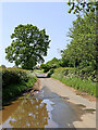
Cottages on Pendeford Hall Lane
Semi detached cottages on the lane from Gunstone to Fordhouses.
Image: © Richard Law
Taken: 6 Apr 2013
0.13 miles
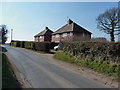
5
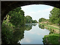
Pendeford Hall Lane near Bilbrook in Staffordshire
Looking east from near Upper Hattons Bridge across the Shropshire Union Canal.
Image: © Roger Kidd
Taken: 21 May 2023
0.14 miles
6
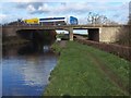
M54 Bridge
Over the Shropshire Union Canal
Image: © Geoff Pick
Taken: 21 Nov 2006
0.15 miles
7
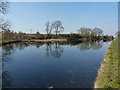
The Upper Hattons 'wide'
A particularly wide section of the Shroppy canal, just north of the Upper Hattons bridge.
Image: © Richard Law
Taken: 6 Apr 2013
0.16 miles
8
Winding Hole on the Shropshire Union
Useful if you decide you have taken a wrong turning.
Image: © John M
Taken: 4 Aug 2007
0.16 miles
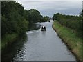
9
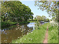
Shropshire Union Canal north of Pendeford, Wolverhampton
Looking north towards Brewood, Wheaton Aston and Market Drayton from beneath Upper Hattons Bridge, No 5. The bridge carries Pendeford Hall Lane.
Image: © Roger Kidd
Taken: 23 Aug 2011
0.16 miles
10
Shropshire Union Canal north-east of Codsall, Staffordshire
Shropshire Union Canal is seen here, looking north towards Brewood, Gnosall and Market Drayton, from near Upper Hattons Bridge, No 5.
The Monarch's Way and Sustrans Route 81 for cyclists both follow the towpath here. https://en.wikipedia.org/wiki/Monarch%27s_Way https://www.sustrans.org.uk/find-a-route-on-the-national-cycle-network/route-81/
Image: © Roger Kidd
Taken: 21 May 2023
0.17 miles