IMAGES TAKEN NEAR TO
Holyhead Road, WOLVERHAMPTON, WV8 2HU
Introduction
This page details the photographs taken nearby to Holyhead Road, WV8 2HU by members of the Geograph project.
The Geograph project started in 2005 with the aim of publishing, organising and preserving representative images for every square kilometre of Great Britain, Ireland and the Isle of Man.

There are currently over 7.5m images from over14,400 individuals and you can help contribute to the project by visiting https://www.geograph.org.uk
Image Map
Images are licensed for reuse under creativecommons.org/licenses/by-sa/2.0
Notes
- Clicking on the map will re-center to the selected point.
- The higher the marker number, the further away the image location is from the centre of the postcode.
Image Listing (40 Images Found)
Images are licensed for reuse under creativecommons.org/licenses/by-sa/2.0
Image
Details
Distance
1
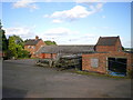
The old farmhouse at The Bradshaws
Part of the original farm buildings at The Bradshaws; these have now been superseded by fancy modern ones, and a newer, bigger house.
Image: © Richard Law
Taken: 30 Jul 2009
0.05 miles
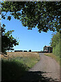
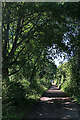
2
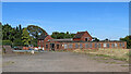
The Bradshaws near Wrottesley in Staffordshire
A bridleway leads off to the right past the boarded up building, towards Cranmoor.
Image: © Roger Kidd
Taken: 9 Jul 2022
0.08 miles
3
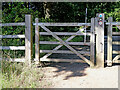
Bridleway gate at The Bradshaws, Wrottesley in Staffordshire
A bridleway from Wrottesley Old Park to Kingswood leads this way.
Image: © Roger Kidd
Taken: 9 Jul 2022
0.09 miles
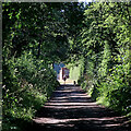
4
Bridleway at The Bradshaws at Wrottesley in Staffordshire
The bridleway down to the right leads towards another, along which the Staffordshire Way and Monarch's Way pass.
Image: © Roger Kidd
Taken: 9 Jul 2022
0.09 miles
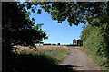
5
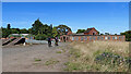
Bridleway at The Bradshaws in Wrottesley Park
Looking north-west towards The Bradshaws and Kingswood.
The Wrottesley Estate existed from the 13th century but was sold off to its tenants in 1963. Wrottesley Park and Wrottesley Old Park remain as marked areas on many maps.
Not all the many farm roads and tracks are public rights of way. This bridleway now turns right at the buildings ahead to go towards Kingswood, not deviating initially to the left as shown on current maps.
Image: © Roger Kidd
Taken: 9 Jul 2022
0.09 miles
6
Bridleway at The Bradshaws in Wrottesley Park
Looking north-west towards The Bradshaws and Kingswood.
The Wrottesley Estate existed from the 13th century but was sold off to its tenants in 1963. Wrottesley Park and Wrottesley Old Park remain as marked areas on many maps. Not all the farm roads and tracks are public rights of way. This bridleway now turns right at the buildings ahead to go towards Kingswood, not deviating initially to the left as shown on current maps.
Image: © Roger Kidd
Taken: 9 Jul 2022
0.09 miles
7
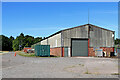
Large shed at the Bradshaws near Wrottesley, Staffordshire
A bridleway from Wrottesley Old Park to Kingswood leads past the large shed on the left (not across the field as shown on some OS maps). Another bridleway leads off to the right towards Cranmoor.
Image: © Roger Kidd
Taken: 9 Jul 2022
0.10 miles
8
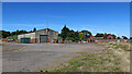
The Bradshaws near Wrottesley in Staffordshire
A bridleway leads past the large shed on the left (not across the field as shown on some OS maps). Another bridleway leads off to the right towards Cranmoor.
Image: © Roger Kidd
Taken: 9 Jul 2022
0.10 miles
9
Bridleway near The Bradshaws in Wrottesley Park
Looking north-west towards The Bradshaws and Kingswood.
The Wrottesley Estate existed from the 13th century but was sold off to its tenants in 1963. Wrottesley Park and Wrottesley Old Park remain as marked areas on many maps.
Not all the many farm roads and tracks are public rights of way.
Image: © Roger Kidd
Taken: 9 Jul 2022
0.10 miles
10
Bridleway in Wrottesley Park, Staffordshire
Looking north-west towards The Bradshaws and Kingswood.
The Wrottesley Estate existed from the 13th century but was sold off to its tenants in 1963. Wrottesley Park and Wrottesley Old Park remain as marked areas on many maps. Not all the many farm roads and tracks are public rights of way.
Image: © Roger Kidd
Taken: 9 Jul 2022
0.11 miles