IMAGES TAKEN NEAR TO
Catisfield Crescent, WOLVERHAMPTON, WV8 1YT
Introduction
This page details the photographs taken nearby to Catisfield Crescent, WV8 1YT by members of the Geograph project.
The Geograph project started in 2005 with the aim of publishing, organising and preserving representative images for every square kilometre of Great Britain, Ireland and the Isle of Man.

There are currently over 7.5m images from over14,400 individuals and you can help contribute to the project by visiting https://www.geograph.org.uk
Image Map
Images are licensed for reuse under creativecommons.org/licenses/by-sa/2.0
Notes
- Clicking on the map will re-center to the selected point.
- The higher the marker number, the further away the image location is from the centre of the postcode.
Image Listing (58 Images Found)
Images are licensed for reuse under creativecommons.org/licenses/by-sa/2.0
Image
Details
Distance
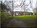
1
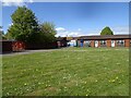
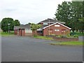
Dovecotes School
The view on the Dovecotes Estate, Pendeford, Wolverhampton.
Image: © Gordon Griffiths
Taken: 6 May 2021
0.07 miles
2
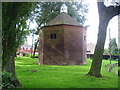
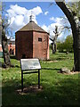
17th century dovecote
In England in the 16th and 17th century having a dovecote became a status symbol. Octagon shaped ones like this one became very popular in the West Midlands in the 17th and 18th century, many examples survive and they were sometimes used as decorative features for large houses.
There were however complaints from local people saying that the doves and pigeons ate too much grain from the crops in the local fields.
Image: © A Holmes
Taken: 1 Aug 2007
0.11 miles
3
Crofters Walk
The view in Pendeford, Wolverhampton.
Image: © Gordon Griffiths
Taken: 25 Feb 2022
0.12 miles
4
Reapers Walk
The view on the Dovecotes Estate, Pendeford, Wolverhampton.
Image: © Gordon Griffiths
Taken: 6 May 2021
0.13 miles
5
Pendeford Seventh-day Adventist Church
A newish church on Ryefield, which is the main road through the housing estate.
Image: © Richard Law
Taken: 12 Jun 2012
0.14 miles
6
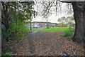
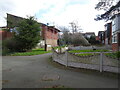
Path to houses on Bridgefoot Walk
A path leading away from the Shropshire Union Canal.
Image: © Bill Boaden
Taken: 10 Nov 2016
0.14 miles
7
Dovecote View
The view on the Dovecotes Estate, Pendeford, Wolverhampton.
Image: © Gordon Griffiths
Taken: 6 May 2021
0.15 miles
8
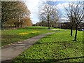
Crocuses Path
The view by the Shropshire Union Canal in Pendeford, Wolverhampton.
Image: © Gordon Griffiths
Taken: 25 Feb 2022
0.15 miles
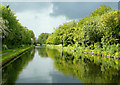
9
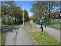
Footpath to Bridgefoot Walk, Ryefield
Seen from the towpath of the Shropshire Union Canal.
Image: © Richard Vince
Taken: 8 Dec 2018
0.16 miles
10
The Shropshire Union Canal near Wolverhampton
Stormy clouds were forming here where the canal cuts through Pendeford and approaches Barnhurst Bridge, No 2.
Note: Nicholson's Canal Guides, and other canal sources refer to this as Bathurst Bridge. As Barnhurst relates to an ancient local family and nearby part of Pendeford, that seems the more likely name for the bridge.
Image: © Roger D Kidd
Taken: 19 May 2009
0.16 miles