IMAGES TAKEN NEAR TO
Ploughmans Walk, WOLVERHAMPTON, WV8 1TU
Introduction
This page details the photographs taken nearby to Ploughmans Walk, WV8 1TU by members of the Geograph project.
The Geograph project started in 2005 with the aim of publishing, organising and preserving representative images for every square kilometre of Great Britain, Ireland and the Isle of Man.

There are currently over 7.5m images from over14,400 individuals and you can help contribute to the project by visiting https://www.geograph.org.uk
Image Map
Images are licensed for reuse under creativecommons.org/licenses/by-sa/2.0
Notes
- Clicking on the map will re-center to the selected point.
- The higher the marker number, the further away the image location is from the centre of the postcode.
Image Listing (101 Images Found)
Images are licensed for reuse under creativecommons.org/licenses/by-sa/2.0
Image
Details
Distance
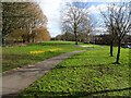
2
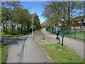
Reapers Walk
The view on the Dovecotes Estate, Pendeford, Wolverhampton.
Image: © Gordon Griffiths
Taken: 6 May 2021
0.06 miles
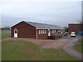
3
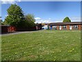
Dovecotes School
The view on the Dovecotes Estate, Pendeford, Wolverhampton.
Image: © Gordon Griffiths
Taken: 6 May 2021
0.07 miles
4
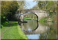
Bathurst Bridge No 2
Carrying a footpath across the Shropshire Union Canal at Pendeford.
Image: © Mat Fascione
Taken: 21 Apr 2018
0.09 miles
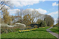
5
Crocuses Path
The view by the Shropshire Union Canal in Pendeford, Wolverhampton.
Image: © Gordon Griffiths
Taken: 25 Feb 2022
0.09 miles
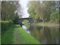
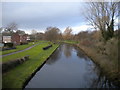
7
Canal north-east of Dovecotes in Wolverhampton
This is the Shropshire Union Canal at Barnhurst Bridge, No 2. Autherley Junction with the Staffordshire and Worcestershire Canal is about 710 metres past the bridge. The Dovecotes estate at Pendeford is off to the right, bult in the 1970s on former Barnhurst Farm fields.
* Nicholson's widely used waterways guides from the 1990s onwards call this Bathurst Bridge, and I assume the CanalPlan website has sourced this for their listing. I suspect this was a typographical error in the production of the guide books. Barnhurst Bridge is a far more likely name, being just 420 yards north-west of the original Barnhurst Farm. https://maps.nls.uk/geo/explore/#zoom=17.0&lat=52.62022&lon=-2.15519&layers=168&b=1
Image: © Roger Kidd
Taken: 8 Apr 2023
0.10 miles
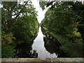
8
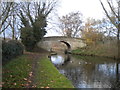
Bridge no. 2, Shropshire Union Canal near Pendeford
Carrying a public footpath that links Ryefield (left) and Pendeford estates.
Image: © Richard Vince
Taken: 8 Dec 2018
0.10 miles
9
Shropshire Union Canal near Pendeford (3)
Looking towards Nantwich from bridge no. 2 as the canal passes Ryefield estate (left).
Image: © Richard Vince
Taken: 8 Dec 2018
0.10 miles
10
Bridge Scene
The view of the Shropshire Union Canal from Bathurst Bridge No2 at Pendeford, Wolverhampton.
Image: © Gordon Griffiths
Taken: 28 Sep 2020
0.10 miles