IMAGES TAKEN NEAR TO
Victor Close, WOLVERHAMPTON, WV7 3NT
Introduction
This page details the photographs taken nearby to Victor Close, WV7 3NT by members of the Geograph project.
The Geograph project started in 2005 with the aim of publishing, organising and preserving representative images for every square kilometre of Great Britain, Ireland and the Isle of Man.

There are currently over 7.5m images from over14,400 individuals and you can help contribute to the project by visiting https://www.geograph.org.uk
Image Map
Images are licensed for reuse under creativecommons.org/licenses/by-sa/2.0
Notes
- Clicking on the map will re-center to the selected point.
- The higher the marker number, the further away the image location is from the centre of the postcode.
Image Listing (46 Images Found)
Images are licensed for reuse under creativecommons.org/licenses/by-sa/2.0
Image
Details
Distance
1
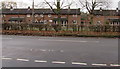
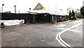
Victor Close housing, Cosford
Housing behind wire fencing in the RAF Cosford site, viewed across Newport Road near the A41 junction.
Image: © Jaggery
Taken: 1 Dec 2015
0.01 miles
2
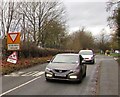
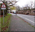
Give way 140 yards ahead, Newport Road, Cosford
Newport Road from Albrighton approaches the A41 junction.
Image: © Jaggery
Taken: 1 Dec 2015
0.02 miles
3
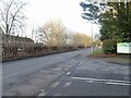
Newport Road
The view near the Garden Centre in Albrighton.
Image: © Gordon Griffiths
Taken: 29 Jan 2023
0.02 miles
4
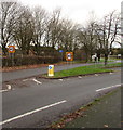
Start of the 40 zone, Newport Road, Cosford
The National Speed Limit on Newport Road from Albrighton drops to 40mph at the A41 junction.
Image: © Jaggery
Taken: 1 Dec 2015
0.04 miles
5
Wyevale garden centre near Cosford
The garden centre entrance road is from Newport Road near the A41 junction,
between Albrighton and Cosford. On December 1st 2015, the large banner shows
Book now - breakfast or tea with Father Christmas. £9.99 per child.
Image: © Jaggery
Taken: 1 Dec 2015
0.04 miles
6
Warning sign - road liable to flooding, Cosford
The red-edged triangular sign is alongside Newport Road, facing the A41 junction.
Image: © Jaggery
Taken: 1 Dec 2015
0.04 miles
7
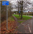
Cycle route 81 distances sign, Cosford
On the corner of Newport Road and the A41, the sign shows National Cycle Network route 81 distances.
Quarter of a mile to Cosford, a mile to the RAF Museum, 5 miles to Shifnal, 10 to Telford.
Image: © Jaggery
Taken: 1 Dec 2015
0.05 miles
8
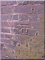
OS benchmark - Albrighton, railway bridge to northwest
An OS cutmark in the bricks of the railway bridge over Newport Road; originally levelled at 86.953m above Ordnance Datum Newlyn.
Image: © Richard Law
Taken: 15 Mar 2014
0.05 miles
9

Garden Centre View
The view inside the Wyevale Garden Centre at Albrighton.
Image: © Gordon Griffiths
Taken: 3 Aug 2015
0.05 miles
10
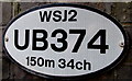
UB374 railway bridge identifier near Cosford
On the roadside wall of this http://www.geograph.org.uk/photo/4758045 bridge over Newport Road.
Image: © Jaggery
Taken: 1 Dec 2015
0.06 miles