IMAGES TAKEN NEAR TO
Millars Green, High Street, WOLVERHAMPTON, WV7 3JS
Introduction
This page details the photographs taken nearby to Millars Green, High Street, WV7 3JS by members of the Geograph project.
The Geograph project started in 2005 with the aim of publishing, organising and preserving representative images for every square kilometre of Great Britain, Ireland and the Isle of Man.

There are currently over 7.5m images from over14,400 individuals and you can help contribute to the project by visiting https://www.geograph.org.uk
Image Map
Images are licensed for reuse under creativecommons.org/licenses/by-sa/2.0
Notes
- Clicking on the map will re-center to the selected point.
- The higher the marker number, the further away the image location is from the centre of the postcode.
Image Listing (108 Images Found)
Images are licensed for reuse under creativecommons.org/licenses/by-sa/2.0
Image
Details
Distance
1
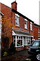
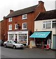
Balance in High Street, Albrighton
Balance Health & Beauty Centre is set back from the south side of High Street.
The Greek letter pi is used for the letter n in the name sign.
Image: © Jaggery
Taken: 1 Dec 2015
0.01 miles
2
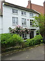
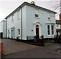
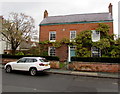
The Grey House, Albrighton
A late 18th century town house, which was Grade II listed https://www.britishlistedbuildings.co.uk/101053703-the-grey-house-albrighton#.WywDoNQrLGg in 1984.
Image: © Richard Law
Taken: 16 Jun 2018
0.01 miles
3
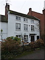
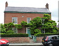
31 High Street, Albrighton
An early-to-mid 18th century town house of three storeys, which was Grade II listed https://britishlistedbuildings.co.uk/101221417-31-high-street-albrighton#.XmjlP6j7RPY & https://historicengland.org.uk/listing/the-list/list-entry/1221417 in 1984.
Image: © Richard Law
Taken: 31 Dec 2019
0.01 miles
4
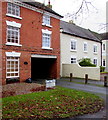
Millers Green, High Street, Albrighton
Two Millers Green names are in view here on the south side of High Street.
One is on the black oval plaque on the wall.
The other one is on the grass above PARKING FOR RESIDENTS ONLY BEYOND THIS POINT.
Image: © Jaggery
Taken: 1 Dec 2015
0.01 miles
5
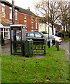
BT phonebox, High Street, Albrighton
The grey phonebox is on the grassy strip on the south side of High Street, next to a telecoms cabinet and a bench.
Image: © Jaggery
Taken: 1 Dec 2015
0.02 miles
6
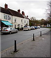
On-street parking, High Street, Albrighton
Parking is allowed on this part of the north side of High Street, whereas
double yellow lines on the south side make parking here illegal at any time.
Image: © Jaggery
Taken: 1 Dec 2015
0.02 miles
7
Holles House, Albrighton
Set back from the south side of High Street.
Image: © Jaggery
Taken: 1 Dec 2015
0.02 miles
8
Conspicuous 76 in High Street, Albrighton
On the awning of Number76 Home & Gifts shop. Premises in this High Street are numbered consecutively (not odds on one side and evens on the other). The chemist shop http://www.geograph.org.uk/photo/4756245 next door is at 77 High Street.
Image: © Jaggery
Taken: 1 Dec 2015
0.02 miles
9
Grade II listed 73 High Street, Albrighton
Late 18th century house, with later additions and alterations. Grade II listed in 1984.
There is a small Birmingham District Fire insurance plate on the wall, between two upper floor windows.
Image: © Jaggery
Taken: 1 Dec 2015
0.02 miles
10
73 High Street, Albrighton
A late 18th century town house, which was Grade II listed https://www.britishlistedbuildings.co.uk/101053698-73-high-street-albrighton#.WywFSdQrLGg in 1984. The 'Birmingham District' fire insurance plate on the upper front wall between the left and central windows is included in the listing details.
Image: © Richard Law
Taken: 16 Jun 2018
0.03 miles