IMAGES TAKEN NEAR TO
Newport Road, WOLVERHAMPTON, WV7 3EH
Introduction
This page details the photographs taken nearby to Newport Road, WV7 3EH by members of the Geograph project.
The Geograph project started in 2005 with the aim of publishing, organising and preserving representative images for every square kilometre of Great Britain, Ireland and the Isle of Man.

There are currently over 7.5m images from over14,400 individuals and you can help contribute to the project by visiting https://www.geograph.org.uk
Image Map
Images are licensed for reuse under creativecommons.org/licenses/by-sa/2.0
Notes
- Clicking on the map will re-center to the selected point.
- The higher the marker number, the further away the image location is from the centre of the postcode.
Image Listing (113 Images Found)
Images are licensed for reuse under creativecommons.org/licenses/by-sa/2.0
Image
Details
Distance
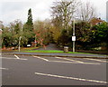
1
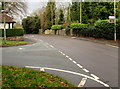
Turn left here for the cricket & tennis club, Albrighton
The white sign on the right points across Newport Road towards Bowling Green Lane. http://www.geograph.org.uk/photo/4757775
Pointing the same way, the brown sign below it shows David Austin Roses Gardens and Plants Centre.
Image: © Jaggery
Taken: 1 Dec 2015
0.01 miles
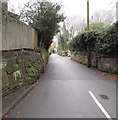
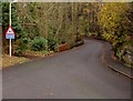
2
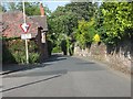
Northern end of Bowling Green Lane
A narrow part of the road presumably reflects an older road layout before the area was laid out with extensive housing estates.
Image: © Peter Whatley
Taken: 8 Jun 2013
0.01 miles
3
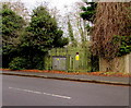
Newport Road electricity substation, Albrighton
The Western Power Distribution electricity substation is in a fenced enclosure alongside Newport Road between Grange Park and Bowling Green Lane. Its identifier is NEWPORT ROAD 0939.
Image: © Jaggery
Taken: 1 Dec 2015
0.02 miles
4
Weight limit ahead, Bowling Green Lane, Albrighton
The sign facing Newport Road shows a 7.5 tonnes weight limit on Bowling Green Lane 500 yards ahead.
Image: © Jaggery
Taken: 1 Dec 2015
0.02 miles
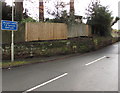
5
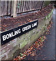
White on black Bowling Green Lane name sign, Albrighton
On the corner of Newport Road.
Image: © Jaggery
Taken: 1 Dec 2015
0.02 miles
6
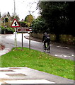
Cycling into Albrighton
A cyclist on Newport Road heads towards High Street and the centre of the village.
Image: © Jaggery
Taken: 1 Dec 2015
0.03 miles
7
Bowling Green Lane, Albrighton
Viewed from the corner of Newport Road.
Image: © Jaggery
Taken: 1 Dec 2015
0.03 miles
8
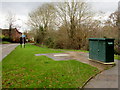
Glass Reinforced Plastic (GRP) cabinet, Newport Road, Albrighton
The only label on this dark green cabinet is that of its manufacturer, Industrial GRP of Ammanford, Carmarthenshire. It took some research to discover that GRP in this case refers to the material from which the cabinet was made - Glass Reinforced Plastic. The cabinet is near several rectangular metal covers on the pavement, so it could be a sewage pumping station. Or it could be a telecoms box which happens to be near pavement covers. It is not an electricity substation nor a gas utility.
Image: © Jaggery
Taken: 1 Dec 2015
0.04 miles
9
Unsuitable route for HGVs, Rectory Road, Donington
The Z-bends and unsuitable for heavy goods vehicles signs face the Newport Road junction at the edge of Albrighton.
Image: © Jaggery
Taken: 1 Dec 2015
0.04 miles
10
Grass triangle junction near Donington
Viewed across Newport Road at the edge of Albrighton. The southern end of Rectory Road
splits into two arms, one on each side of a grass triangle behind the Newport Road pavement.
Image: © Jaggery
Taken: 1 Dec 2015
0.04 miles