IMAGES TAKEN NEAR TO
Delaware Avenue, WOLVERHAMPTON, WV7 3BW
Introduction
This page details the photographs taken nearby to Delaware Avenue, WV7 3BW by members of the Geograph project.
The Geograph project started in 2005 with the aim of publishing, organising and preserving representative images for every square kilometre of Great Britain, Ireland and the Isle of Man.

There are currently over 7.5m images from over14,400 individuals and you can help contribute to the project by visiting https://www.geograph.org.uk
Image Map
Images are licensed for reuse under creativecommons.org/licenses/by-sa/2.0
Notes
- Clicking on the map will re-center to the selected point.
- The higher the marker number, the further away the image location is from the centre of the postcode.
Image Listing (59 Images Found)
Images are licensed for reuse under creativecommons.org/licenses/by-sa/2.0
Image
Details
Distance
1
St Cuthbert's Crescent meets Bowling Green Lane
Image: © Peter Whatley
Taken: 8 Jun 2013
0.12 miles
2
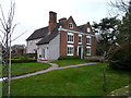
The Elms, Albrighton
Thought to be late 16th or early 17th century, but obviously much altered and extended over the years. The two front gables probably represent the oldest parts of the house, and are timber-framed with a brick facing. The whole building attracted a Grade II listing https://britishlistedbuildings.co.uk/101053692-the-elms-albrighton#.Xmjgcqj7RPY & https://historicengland.org.uk/listing/the-list/list-entry/1053692 in 1984.
Image: © Richard Law
Taken: 31 Dec 2019
0.13 miles
3
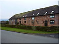
Listed barn near The Elms
The fabric of the barn is thought to be 18th century, particularly the far end which still displays its timber frmming, although the nearer end has been rebuilt, most likely in the 19th. The whole structure attracted a Grade II listing https://britishlistedbuildings.co.uk/101367612-barn-about-60-metres-south-east-of-the-elms-albrighton & https://historicengland.org.uk/listing/the-list/list-entry/1367612 in 1984. Unsurprisingly, it's now converted to housing.
Image: © Richard Law
Taken: 31 Dec 2019
0.14 miles
4
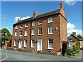
2 & 4 Church Road, Albrighton
2 quite grand, early 19th century terraced houses on Church Road. They attracted a collective Grade II listing https://britishlistedbuildings.co.uk/101367611-2-and-4-church-road-albrighton#.YZYGQ9DP2Uk & https://historicengland.org.uk/listing/the-list/list-entry/1367611 in 1984.
Image: © Richard Law
Taken: 19 Jul 2020
0.19 miles
5
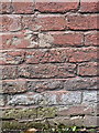
OS benchmark - Albrighton, Bowling Green Lane
The rather badly damaged remains of an OS cutmark in the brickwork of a building on the north side of Bowling Green Lane; originally levelled in 1959 at 93.632m above Ordnance Datum Newlyn.
Image: © Richard Law
Taken: 11 May 2014
0.19 miles
6
Corner of Church Road and High Street, Albrighton
On December 1st 2015, a sign behind the CHURCH ROAD name sign shows
2 BEDROOM APARTMENT FOR RENT.
Image: © Jaggery
Taken: 1 Dec 2015
0.19 miles
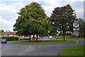
7
Bowling Green Lane Island
The view in Albrighton.
Image: © Gordon Griffiths
Taken: 20 Jun 2018
0.20 miles
8
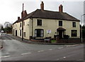
The Shrewsbury Arms, Albrighton
A long-established pub on the old A41 road through Albrighton; there appear to be some refurbishments taking place in mid 2009, and it's to be hoped the place will re-open afterwards.
Image: © Richard Law
Taken: 24 Jul 2009
0.20 miles
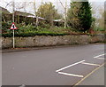
9
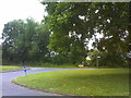
Roundabout at the top of Bowling Green Lane
Fntering the urban area.
Image: © John M
Taken: 8 Oct 2013
0.20 miles
10
Warning sign - staggered crossroads ahead, Newport Road, Albrighton
Facing the Whiteladies Court junction, the red-edged triangular sign is on the approach to the minor junctions
of Rectory Road and Bowling Green Lane, about 40 metres apart on opposite sides of Newport Road.
Image: © Jaggery
Taken: 1 Dec 2015
0.20 miles