IMAGES TAKEN NEAR TO
Donington Lane, WOLVERHAMPTON, WV7 3AD
Introduction
This page details the photographs taken nearby to Donington Lane, WV7 3AD by members of the Geograph project.
The Geograph project started in 2005 with the aim of publishing, organising and preserving representative images for every square kilometre of Great Britain, Ireland and the Isle of Man.

There are currently over 7.5m images from over14,400 individuals and you can help contribute to the project by visiting https://www.geograph.org.uk
Image Map
Images are licensed for reuse under creativecommons.org/licenses/by-sa/2.0
Notes
- Clicking on the map will re-center to the selected point.
- The higher the marker number, the further away the image location is from the centre of the postcode.
Image Listing (6 Images Found)
Images are licensed for reuse under creativecommons.org/licenses/by-sa/2.0
Image
Details
Distance
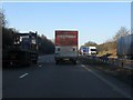
1
High Holborn
Inspite the name it's nowhere near London.
Image: © Row17
Taken: 18 Apr 2008
0.01 miles
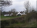
2
Farmland off Donington Lane
The skyline is dominated by the shiny silver Cold War Exhibition at RAF Cosford. This is visible for many miles around and is out of character in this rural view. Wouldn't it have been more fitting if it had blended into the landscape.
Image: © John M
Taken: 8 Apr 2007
0.08 miles
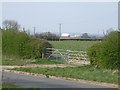
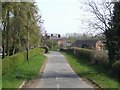
3
Lane junction near Donington House Farm
Image: © Richard Law
Taken: 16 May 2010
0.11 miles
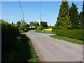
4
Lower Wood Farm
Private access road to the farms in countryside south of the M54.
Image: © John M
Taken: 8 Apr 2007
0.15 miles
5
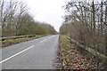
Looking in the direction of Cosford from M54 bridge
Image: © Mick Malpass
Taken: 12 Jan 2014
0.17 miles