IMAGES TAKEN NEAR TO
Aldersley Road, WOLVERHAMPTON, WV6 9NB
Introduction
This page details the photographs taken nearby to Aldersley Road, WV6 9NB by members of the Geograph project.
The Geograph project started in 2005 with the aim of publishing, organising and preserving representative images for every square kilometre of Great Britain, Ireland and the Isle of Man.

There are currently over 7.5m images from over14,400 individuals and you can help contribute to the project by visiting https://www.geograph.org.uk
Image Map
Images are licensed for reuse under creativecommons.org/licenses/by-sa/2.0
Notes
- Clicking on the map will re-center to the selected point.
- The higher the marker number, the further away the image location is from the centre of the postcode.
Image Listing (91 Images Found)
Images are licensed for reuse under creativecommons.org/licenses/by-sa/2.0
Image
Details
Distance
1
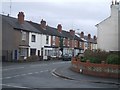
Terraced housing on Aldersley Road
This housing backs on to the Smestow Brook and railway embankment.
Image: © John M
Taken: 30 Dec 2006
0.04 miles
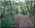
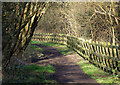
2
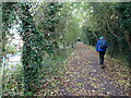
Railway Path
The view along the railway path in Claregate, Wolverhampton.
Image: © Gordon Griffiths
Taken: 27 Oct 2021
0.05 miles
3
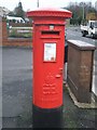
Edward VIII Postbox
This listed postbox is at the corner of Burland Avenue and Aldersley Road. It is unusual in that only 161 were cast and very few are known to remain in use.
Image: © John M
Taken: 30 Dec 2006
0.05 miles
4
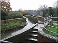
Smestow Brook crossing the Tunstall Water Bridge
The Smestow Brook is carried over the Staffs & Worcs Canal on this brick arch bridge. The brook was not diverted into the canal as it powered mills further downstream. This was taken after wet weather when levels were high.
Image: © John M
Taken: 25 Nov 2006
0.05 miles
5
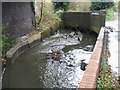
Under the railway bridge
The Smestow Brook swollen with overnight stormwater looks and smells polluted.
Image: © John M
Taken: 25 Nov 2006
0.05 miles
6
Railway Path View
The view along the railway path in Claregate, Wolverhampton.
Image: © Gordon Griffiths
Taken: 27 Oct 2021
0.07 miles
7
Dismantled Railway, Aldersley, Wolverhampton
The railway, opened in 1925, was closed to passengers within 7 years. Read all about the whole line by going here http://www.railaroundbirmingham.co.uk/regional_map.php then clicking on each station starting with Tettenhall.
Image: © Roger D Kidd
Taken: 8 Feb 2008
0.07 miles
8
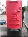
Wolverhampton, EVIIIR postbox detail
Detail of Image, on Aldersley Road, showing the royal cypher of Edward the Eighth.
Image: © Mike Faherty
Taken: 8 Jun 2009
0.07 miles
9
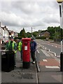
Wolverhampton, EVIIIR postbox
Unusual Edward the Eighth postbox at the junction of Aldersley Road & Burland Avenue; at a previous visit, the front of the box was obscured by the litterbin. Perhaps the Post Office has told the shopkeeper to move it; this is just being done. For a close-up of the royal cypher, see Image
Image: © Mike Faherty
Taken: 8 Jun 2009
0.07 miles
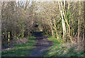
10
Dismantled Railway, Claregate, Wolverhampton
The track has long since gone, and the bed is now used as a leisure walkway, linking with Smestow Valley Nature Reserve and the South Staffordshire Railway Walk to Kingswinford.
The nearest station to this point was at Tettenhall. http://www.railaroundbirmingham.co.uk/Stations/tettenhall.php
Image: © Roger D Kidd
Taken: 8 Feb 2008
0.08 miles