IMAGES TAKEN NEAR TO
Yew Tree Lane, WOLVERHAMPTON, WV6 8UW
Introduction
This page details the photographs taken nearby to Yew Tree Lane, WV6 8UW by members of the Geograph project.
The Geograph project started in 2005 with the aim of publishing, organising and preserving representative images for every square kilometre of Great Britain, Ireland and the Isle of Man.

There are currently over 7.5m images from over14,400 individuals and you can help contribute to the project by visiting https://www.geograph.org.uk
Image Map (106 Images)


Getting Data...Please wait
Leaflet Map data © OpenStreetMap
Images are licensed for reuse under creativecommons.org/licenses/by-sa/2.0
Notes
- Clicking on the map will re-center to the selected point.
- The higher the marker number, the further away the image location is from the centre of the postcode.
Image Listing (106 Images Found)
Images are licensed for reuse under creativecommons.org/licenses/by-sa/2.0
Image
Details
Distance
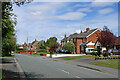
1
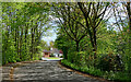
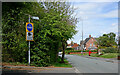
Bikes and buses only near Perton, Staffordshire
Perton is in Staffordshire. Yew Tree Lane (ahead) is in Wolverhampton.
The only road out of Perton to the east is this one, not available to the public. That lovely bungalow is about a hundred metres away. Anyone driving there from Perton Middle School (off to the left) must go via Wrottesley Park Road away to the west, a diversion of three miles.
Image]
Image: © Roger D Kidd
Taken: 30 Apr 2024
0.03 miles
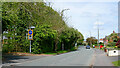
3
Perton bus link, Tettenhall Wood
Providing a direct link for buses into Perton from the east, which enables them to travel more directly between the estate and Wolverhampton city centre than would be possible via Perton's other vehicular links to the outside world. Seen from Yew Tree Lane.
Image: © Richard Vince
Taken: 23 Dec 2017
0.05 miles
4
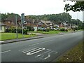
Tettenhall housing in Yew Tree Lane, Wolverhampton
Looking north towards the junction with Woodthorne Road South.
Image: © Roger D Kidd
Taken: 30 Apr 2024
0.05 miles
5
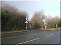
Restricted road access to Perton
The former wartime RAF Perton site was developed for housing between 1974 and 1989. To avoid traffic congestion in the small lanes in the neighbouring areas of Wolverhampton the only road access to the village is on the western side from Jenny Walker's Lane. However, special provision was made for buses which use this special 'bus gateway' controlled by traffic lights and barrier. This reduces the journey into Wolverhampton by several miles.
Image: © John M
Taken: 5 Jan 2008
0.07 miles
6
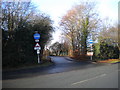
Yew Tree Lane in Tettenhall, Wolverhampton
Looking north-north-west towards Codsall. The Wolverhampton/Staffordshire boundary runs along this road, Perton in Staffordshire being off to the left but no public road allows access from Yew Tree Lane. Drivers going to Perton Middle School (off to the left) face a permanent three mile diversion via Wrottesley Park Road.
Image: © Roger D Kidd
Taken: 30 Apr 2024
0.07 miles
8
Yew Tree Lane in Tettenhall, Wolverhampton
Looking north towards Codsall. The Wolverhampton/Staffordshire boundary runs along this road, Perton in Staffordshire being off to the left but no public road allows access from Yew Tree Lane. Drivers going to Perton Middle School (adjacent, off to the left) face a permanent three mile diversion via Wrottesley Park Road.
Image: © Roger D Kidd
Taken: 30 Apr 2024
0.08 miles
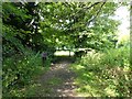
9
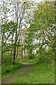
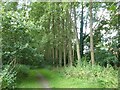
Woodland track in Perton, Staffordshire
Looking west-north-west, the unnamed bus lane by the school is off to the right.
Image: © Roger D Kidd
Taken: 30 Apr 2024
0.08 miles