IMAGES TAKEN NEAR TO
Station Buildings, Henwood Road, WOLVERHAMPTON, WV6 8NY
Introduction
This page details the photographs taken nearby to Station Buildings, Henwood Road, WV6 8NY by members of the Geograph project.
The Geograph project started in 2005 with the aim of publishing, organising and preserving representative images for every square kilometre of Great Britain, Ireland and the Isle of Man.

There are currently over 7.5m images from over14,400 individuals and you can help contribute to the project by visiting https://www.geograph.org.uk
Image Map
Images are licensed for reuse under creativecommons.org/licenses/by-sa/2.0
Notes
- Clicking on the map will re-center to the selected point.
- The higher the marker number, the further away the image location is from the centre of the postcode.
Image Listing (174 Images Found)
Images are licensed for reuse under creativecommons.org/licenses/by-sa/2.0
Image
Details
Distance
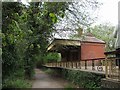
1
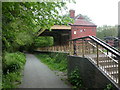
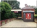
Tettenhall, park rangers' office
Office situated at the previous Tettenhall Station on the former Dunstall Park to Brierley Hill railway line Image; now, office for Smestow Valley Nature Reserve http://www.wolverhampton.gov.uk/leisure_culture/parks_recreation/countryside/nature_reserves/smestow_valley.htm
Image: © Mike Faherty
Taken: 26 Apr 2009
0.00 miles
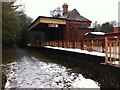
2
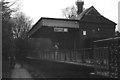
Tettenhall station
Formerly used as a ranger station but now open as a tea room. The station opened (with two platforms, one of which never had track laid to serve it and was never used) in 1925 and closed in 1932. The site is remarkably complete: the goods shed, weighbridge hut and both platforms survive.
Image: © John Winder
Taken: 7 Dec 2014
0.00 miles
3
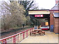
Cupcake Cafe
The view of the café on the Smestow Valley Local Nature Reserve in the former Tettenhall Railway Station.
Image: © Gordon Griffiths
Taken: 3 Feb 2017
0.00 miles
4
Cupcake Lane
The view of the Tea Room on the Smestow Valley Local Nature Reserve in the former Tettenhall Railway Station.
Image: © Gordon Griffiths
Taken: 28 Sep 2020
0.00 miles
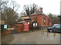
6

Station View
The Ranger Office for Smestow Valley Local Nature Reserve in the former Tettenhall Railway Station.
Image: © Gordon Griffiths
Taken: 29 Oct 2013
0.01 miles
8
Station Scene
The view of the café on the Smestow Valley Local Nature Reserve in the former Tettenhall Railway Station.
Image: © Gordon Griffiths
Taken: 4 Feb 2017
0.01 miles
9
Cupcake Lane in winter
Cafe called Cupcake Lane in the former Tettenhall railway station, Wolverhampton. Other buildings on the site house an amateur transport museum. Tettenhall station was on the Wombourne branch line and opened in 1925, but it closed seven years later for want of custom. The tracks were taken up in the 1960s and the line has become a footpath, but the station has survived intact. There are now proposals to open a new station in Tettenhall, but it would be on the main line to Telford and Shrewsbury. https://en.wikipedia.org/wiki/Tettenhall_railway_station
Image: © A J Paxton
Taken: 17 Dec 2017
0.01 miles
10
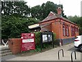
Tettenhall Railway Station
The old railway station on the GWR line closed in the 1960s is now used as a Ranger Station for the Valley Park. The line opened in the 1920s and was mainly restricted to freight use.
Image: © John M
Taken: 21 Apr 2007
0.01 miles