IMAGES TAKEN NEAR TO
Bridgnorth Road, WOLVERHAMPTON, WV6 8BL
Introduction
This page details the photographs taken nearby to Bridgnorth Road, WV6 8BL by members of the Geograph project.
The Geograph project started in 2005 with the aim of publishing, organising and preserving representative images for every square kilometre of Great Britain, Ireland and the Isle of Man.

There are currently over 7.5m images from over14,400 individuals and you can help contribute to the project by visiting https://www.geograph.org.uk
Image Map (Loading...)


Getting Data...Please wait
Leaflet Map data © OpenStreetMap
Images are licensed for reuse under creativecommons.org/licenses/by-sa/2.0
Notes
- Clicking on the map will re-center to the selected point.
- The higher the marker number, the further away the image location is from the centre of the postcode.
Image Listing (342 Images Found)
Images are licensed for reuse under creativecommons.org/licenses/by-sa/2.0
Image
Details
Distance
1
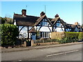
256 & 258 Bridgnorth Road
A pair of houses, built around 1890 as part of an incomplete planned estate associated with the nearby Wghtwick Manor, and Grade II listed https://britishlistedbuildings.co.uk/101201782-256-and-258-bridgnorth-road-tettenhall-wightwick-ward#.YhJYmOjP3IU & https://historicengland.org.uk/listing/the-list/list-entry/1201782 in 1992. Others of the same style include Image & Image
Image: © Richard Law
Taken: 4 Feb 2022
0.01 miles
2
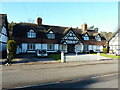
248 to 254 Bridgnorth Road
A terrace of 4 houses, built around 1890, for the industrialist Theodore Mander who lived nearby at Image, and wanted a planned village of fine houses around his estate. The village idea rather petered out, apart from a few buildings that survive here alongside the main road, such as Image & Image These 4 were Grade II listed https://britishlistedbuildings.co.uk/101205104-248-254-bridgnorth-road-tettenhall-wightwick-ward#.YhJWSujP3IU & https://historicengland.org.uk/listing/the-list/list-entry/1205104 in 1992.
Image: © Richard Law
Taken: 4 Feb 2022
0.01 miles
4
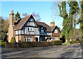
260 to 264 Bridgnorth Road
A row of 3 houses, built around 1890, for the industrialist Theodore Mander who lived nearby at Image, and wanted a planned village of fine houses around his estate. The village idea rather petered out, apart from a few buildings that survive here alongside the main road, such as Image & Image These 3 were Grade II listed https://britishlistedbuildings.co.uk/101282487-260-262-and-264-bridgnorth-road-tettenhall-wightwick-ward#.YhJZnejP3IU & https://historicengland.org.uk/listing/the-list/list-entry/1282487 in 1992.
Image: © Richard Law
Taken: 4 Feb 2022
0.02 miles
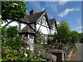
5

244 & 246 Bridgnorth Road
A pair of houses, built around 1890 as part of an incomplete planned estate associated with the nearby Wghtwick Manor, and Grade II listed https://britishlistedbuildings.co.uk/101282486-244-rock-bottom-and-246-bridgnorth-road-tettenhall-wightwick-ward#.YhIm8ejP3IU & https://historicengland.org.uk/listing/the-list/list-entry/1282486 in 1992. There are a number of other houses of a similar nature just to the west Image Image & Image
Image: © Richard Law
Taken: 4 Feb 2022
0.02 miles
6
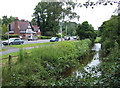
Smestow Brook and A454, Wightwick, near Wolverhampton
Considering the recent heavy rain, the brook appears quite benign today.
Image: © Roger Kidd
Taken: 23 Jun 2007
0.03 miles
7
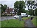
Bridgnorth Road (A454), Wightwick
At a busy junction.
Image: © JThomas
Taken: 8 Jun 2019
0.05 miles
8
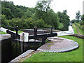
Wightwick Lock, and Bridge, Staffordshire and Worcestershire Canal
Wightwick Bridge (No.57), immediately below the bottom gates of the lock, was purely a farmers' access bridge connecting land each side of the canal. The lock drops the level 2.64 metres (8 ft. 8in.). The 46 mile canal, from Great Haywood to the River Severn was opened in 1772 at a cost of rather over £100,000.
Image: © Roger Kidd
Taken: 23 Jun 2007
0.05 miles
10
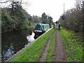
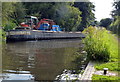
Hamwih Mooring
The view on the Staffordshire and Worcestershire canal near Wightwick, Wolverhampton.
Image: © Gordon Griffiths
Taken: 30 Nov 2021
0.05 miles