IMAGES TAKEN NEAR TO
Bridgnorth Road, WOLVERHAMPTON, WV6 8AG
Introduction
This page details the photographs taken nearby to Bridgnorth Road, WV6 8AG by members of the Geograph project.
The Geograph project started in 2005 with the aim of publishing, organising and preserving representative images for every square kilometre of Great Britain, Ireland and the Isle of Man.

There are currently over 7.5m images from over14,400 individuals and you can help contribute to the project by visiting https://www.geograph.org.uk
Image Map
Images are licensed for reuse under creativecommons.org/licenses/by-sa/2.0
Notes
- Clicking on the map will re-center to the selected point.
- The higher the marker number, the further away the image location is from the centre of the postcode.
Image Listing (140 Images Found)
Images are licensed for reuse under creativecommons.org/licenses/by-sa/2.0
Image
Details
Distance
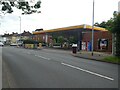
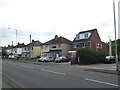
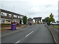
2
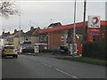
Total filling station, Bridgnorth Road
Image: © Peter Whatley
Taken: 17 Jan 2012
0.04 miles
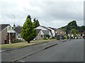
6
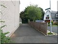
Public footpath off Cherrington Gardens
Image: © ElfExplorer
Taken: 29 Aug 2024
0.07 miles
8
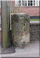
Old Milestone by the A454, Bridgnorth Road, Compton
Stone post (plates lost) by the A454, in parish of WOLVERHAMPTON (WOLVERHAMPTON District), Compton, Bridgnorth Road, by No. 155, in pavement in front of brick wall, on North West side of road. Wolverhampton iron plate, erected by the Wolverhampton, Old District turnpike trust in the 19th century.
Inscription once read:-
: (Bridgnorth / 11½) : : (Wolverhampton / 2) :
Carved bench mark on left face.
Milestone Society National ID: ST_WVBN02
Image: © Mike Faherty
Taken: 14 Mar 2008
0.08 miles
9
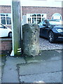
The old Compton milestone
Originally this sported metal plates (probably cast iron) which read 11.5 miles to Bridgnorth and 2 miles into Wolverhampton, but sadly those have been lost/stolen/melted down, as is the case with the very similar stone a mile to the east Image
Image: © Richard Law
Taken: 4 Feb 2022
0.08 miles
10
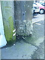
OS benchmark - Compton, former milestone
An OS cutmark low on the eastern face of the former Compton milestone, last levelled in 1957 at 102.303m above Ordnance Datum Newlyn. It was originally cut as part of the 1st Geodetic Levelling survey, and recorded at 336.5ft above Liverpool datum.
Image: © Richard Law
Taken: 4 Feb 2022
0.08 miles