IMAGES TAKEN NEAR TO
Tasman Grove, WOLVERHAMPTON, WV6 7SF
Introduction
This page details the photographs taken nearby to Tasman Grove, WV6 7SF by members of the Geograph project.
The Geograph project started in 2005 with the aim of publishing, organising and preserving representative images for every square kilometre of Great Britain, Ireland and the Isle of Man.

There are currently over 7.5m images from over14,400 individuals and you can help contribute to the project by visiting https://www.geograph.org.uk
Image Map (Loading...)


Getting Data...Please wait
Leaflet Map data © OpenStreetMap
Images are licensed for reuse under creativecommons.org/licenses/by-sa/2.0
Notes
- Clicking on the map will re-center to the selected point.
- The higher the marker number, the further away the image location is from the centre of the postcode.
Image Listing (192 Images Found)
Images are licensed for reuse under creativecommons.org/licenses/by-sa/2.0
Image
Details
Distance
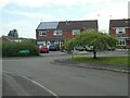
2

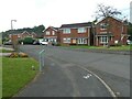
Footpath to Tasmin Grove in Perton, Staffordshire
This footpath is link between Shackleton Drive and Tasmin Grove. Whether you are driving or walking in Perton, I advise you to either know where you are going, or have a good street map and know how to use it. The layout of Perton is almost maze-like with many footpaths linking bendy "Drives" and "Groves" and "Closes". Bear in mind there is no public road east or south out of Perton. The main road (The Parkway) goes round in a "circle". "Vehicles (apart from buses) must exit via Wrottesley Park Road on the west side.
Perton in South Staffordshire is a large village, effectively the edge of the Wolverhampton conurbation. Much of it was built in the late 20th century and early 21st century on the site of the former Perton Aerodrome which closed in July 1947, and adjacent farmland. https://pertonparishcouncil.gov.uk/about-the-parish/history-of-the-parish/ Since 2023 the village has started expanding into farmland west of Wrottesley Park Road.
Image: © Roger D Kidd
Taken: 2 Apr 2024
0.02 miles
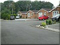
3

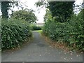
Tasmin Grove in Perton in Staffordshire
Looking north from the footpath linking Shackleton Drive (behind the camera).
Perton in South Staffordshire is a large village, effectively the edge of the Wolverhampton conurbation. Much of it was built in the late 20th century and early 21st century on the site of the former Perton Aerodrome which closed in July 1947, and adjacent farmland. https://pertonparishcouncil.gov.uk/about-the-parish/history-of-the-parish/ Since 2023 the village has started expanding into farmland west of Wrottesley Park Road.
Image: © Roger D Kidd
Taken: 2 Apr 2024
0.02 miles
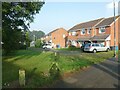
5
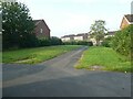
Path between Shackleton Drive and Tasman Grove
Image: © ElfExplorer
Taken: 10 Sep 2023
0.04 miles
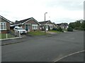
6
Path between Gaydon Close and Shackleton Drive
Image: © ElfExplorer
Taken: 9 Sep 2023
0.04 miles
7
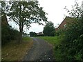
Path between Shackleton Drive and Gaydon Close
Image: © ElfExplorer
Taken: 10 Sep 2023
0.04 miles