IMAGES TAKEN NEAR TO
Berkeley Close, WOLVERHAMPTON, WV6 7RX
Introduction
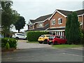
This page details the photographs taken nearby to Berkeley Close, WV6 7RX by members of the Geograph project.
The Geograph project started in 2005 with the aim of publishing, organising and preserving representative images for every square kilometre of Great Britain, Ireland and the Isle of Man.

There are currently over 7.5m images from over14,400 individuals and you can help contribute to the project by visiting https://www.geograph.org.uk
Image Map
Images are licensed for reuse under creativecommons.org/licenses/by-sa/2.0
Notes
- Clicking on the map will re-center to the selected point.
- The higher the marker number, the further away the image location is from the centre of the postcode.
Image Listing (86 Images Found)
Images are licensed for reuse under creativecommons.org/licenses/by-sa/2.0
Image
Details
Distance
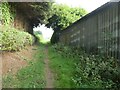
1
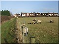
Sheep grazing beside the footpath
The footpath crosses the narrow strip of land between Wightwick and Perton.
Image: © John M
Taken: 5 Jan 2008
0.03 miles
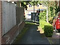
2
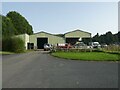
Barns at Boundary Farm
This farm is in the narrow strip of land between Perton and Wolverhampton.
Image: © John M
Taken: 5 Jan 2008
0.07 miles
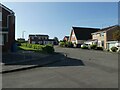
3
Junction of Richmond Drive and Rockingham Drive
Image: © ElfExplorer
Taken: 7 Sep 2023
0.08 miles
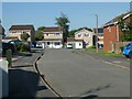
4
Junction of Richmond Drive and Stokesay Avenue
Image: © Kelly
Taken: 4 Sep 2023
0.08 miles
7
Junction of Richmond Drive and Stokesay Avenue
Image: © Kelly
Taken: 4 Sep 2023
0.10 miles
9
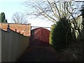
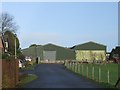
Boundary wall and gateway to Perton Grange
Although the Grange has disappeared under a housing development traces survive in odd places. Here part of the wall and elsewhere the ornamental trees.
Image: © John M
Taken: 5 Jan 2008
0.11 miles