IMAGES TAKEN NEAR TO
Badger, WOLVERHAMPTON, WV6 7JU
Introduction
This page details the photographs taken nearby to WV6 7JU by members of the Geograph project.
The Geograph project started in 2005 with the aim of publishing, organising and preserving representative images for every square kilometre of Great Britain, Ireland and the Isle of Man.

There are currently over 7.5m images from over14,400 individuals and you can help contribute to the project by visiting https://www.geograph.org.uk
Image Map
Images are licensed for reuse under creativecommons.org/licenses/by-sa/2.0
Notes
- Clicking on the map will re-center to the selected point.
- The higher the marker number, the further away the image location is from the centre of the postcode.
Image Listing (35 Images Found)
Images are licensed for reuse under creativecommons.org/licenses/by-sa/2.0
Image
Details
Distance
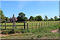
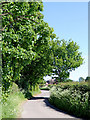
1
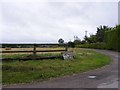
Badger Heath Farm View
The view from the lane to Badger Village.
Image: © Gordon Griffiths
Taken: 20 Aug 2010
0.04 miles
2
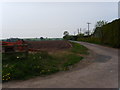
Badger Heath Farm
Lane at Badger Heath leading to Badger Heath Farm and Dingle Cottage.
Image: © A Holmes
Taken: 21 Apr 2007
0.08 miles
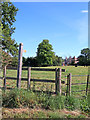
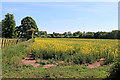
3
Pasture east of Badger in Shropshire
The pasture here is north-west of Badger Heath Farm.
Image: © Roger Kidd
Taken: 19 May 2020
0.10 miles
4
Pasture and footpath east of Badger in Shropshire
The pasture is by Badger Heath Farm. The footpath to Tyte Farm near Ackleton via Badger Dingle is actually this side of the metal fence, not across the field as the sign appears to indicate.
Image: © Roger Kidd
Taken: 19 May 2020
0.10 miles
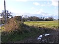
5
Pasture and footpath east of Badger in Shropshire
The pasture is by Badger Heath Farm. The footpath to Tyte Farm near Ackleton, via Badger Dingle is actually this side of the iron fence, not across the field as the sign appears to indicate.
Image: © Roger Kidd
Taken: 19 May 2020
0.12 miles
6
Lane east of Badger in Shropshire
Badger Heath Farm house can be seen through the trees. The footpath off to the left crosses fields and Badger Dingle towards the road by Tyte Farm.
Image: © Roger Kidd
Taken: 19 May 2020
0.13 miles
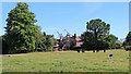
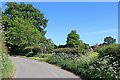
7
Lodge View
The view across the field towards Badger Lodge in Shropshire.
Image: © Gordon Griffiths
Taken: 18 Feb 2016
0.13 miles
8
Path to the Dingle
The view from the lane towards Badger Dingle in Shropshire.
Image: © Gordon Griffiths
Taken: 29 Aug 2017
0.14 miles
9
Lane east of Badger in Shropshire
Looking south-east from near Badger Lodge.
Image: © Roger Kidd
Taken: 19 May 2020
0.14 miles
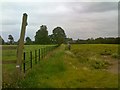
10
Rapefield and footpath near Badger in Shropshire
Looking south, the public footpath follows the edge of the field for two hundred metres, then continues across the field, through the crop to Badger Dingle, then on to the road by Tyte Farm. The yellow flowering of the rape seed plants has almost finished and the crop is up to 1·5 metres high, but the route is just about discernible, thanks to the few walkers who have used it previously.
Image: © Roger Kidd
Taken: 19 May 2020
0.14 miles