IMAGES TAKEN NEAR TO
Snowdon Road, WOLVERHAMPTON, WV6 7HU
Introduction
This page details the photographs taken nearby to Snowdon Road, WV6 7HU by members of the Geograph project.
The Geograph project started in 2005 with the aim of publishing, organising and preserving representative images for every square kilometre of Great Britain, Ireland and the Isle of Man.

There are currently over 7.5m images from over14,400 individuals and you can help contribute to the project by visiting https://www.geograph.org.uk
Image Map
Images are licensed for reuse under creativecommons.org/licenses/by-sa/2.0
Notes
- Clicking on the map will re-center to the selected point.
- The higher the marker number, the further away the image location is from the centre of the postcode.
Image Listing (41 Images Found)
Images are licensed for reuse under creativecommons.org/licenses/by-sa/2.0
Image
Details
Distance
1
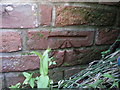
OS benchmark - Burnhill Green, The Old Smithy
An OS cutmark on the wall of The Old Smithy (now a private residence); originally levelled at 83.729m above Ordnance Datum Newlyn.
Image: © Richard Law
Taken: 22 May 2016
0.02 miles
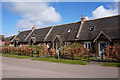
4
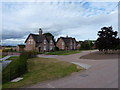
New-build almshouses, Burnhill Green
Part of a community development of 10 homes within Burnhill Green, using materials sourced locally as far as possible, and with a series of environmentally-friendly design features (ground-source heat pumps, rainwater harvesting for use within the houses, sheeps-wool insulation, FSC timber, recycled tiles, etc) to reduce their carbon footprints. The village green is also to be re-instated as part of the work.
This row of 4 almshouses has been built, along with the semis in Image
Image: © Richard Law
Taken: 9 Jul 2010
0.02 miles
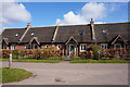
5
New-build semis, Burnhill Green
Part of a community development of 10 homes within Burnhill Green, using materials sourced locally as far as possible, and with a series of environmentally-friendly design features (ground-source heat pumps, rainwater harvesting for use within the houses, sheeps-wool insulation, FSC timber, recycled tiles, etc) to reduce their carbon footprints. The village green is also to be re-instated as part of the work.
A row of 4 almshouses has been built, just to the left of these semis.
Image: © Richard Law
Taken: 9 Jul 2010
0.02 miles
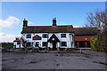
7
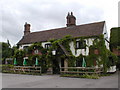
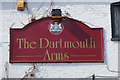
The Dartmouth Arms at Burnhill Green
I understand this pub has now ceased trading - I hope I've been misinformed.
Image: © Row17
Taken: 19 Jun 2002
0.04 miles
8
The Dartmouth Arms, Burnhill Green
http://www.geograph.org.uk/photo/4897998
Image: © Ian S
Taken: 31 Mar 2016
0.04 miles
9
The Dartmouth Arms, Burnhill Green
http://www.geograph.org.uk/photo/4898000
Image: © Ian S
Taken: 31 Mar 2016
0.04 miles
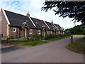
10

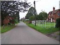
Dartmouth Arms
The view off Snowdon Lane in Burnhill Green.
Image: © Gordon Griffiths
Taken: 20 Aug 2010
0.05 miles