IMAGES TAKEN NEAR TO
Snowdon Road, WOLVERHAMPTON, WV6 7HS
Introduction
This page details the photographs taken nearby to Snowdon Road, WV6 7HS by members of the Geograph project.
The Geograph project started in 2005 with the aim of publishing, organising and preserving representative images for every square kilometre of Great Britain, Ireland and the Isle of Man.

There are currently over 7.5m images from over14,400 individuals and you can help contribute to the project by visiting https://www.geograph.org.uk
Image Map
Images are licensed for reuse under creativecommons.org/licenses/by-sa/2.0
Notes
- Clicking on the map will re-center to the selected point.
- The higher the marker number, the further away the image location is from the centre of the postcode.
Image Listing (11 Images Found)
Images are licensed for reuse under creativecommons.org/licenses/by-sa/2.0
Image
Details
Distance
1
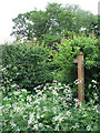
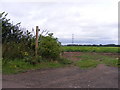
Public Footpath "through" Hedge, Shropshire
Yeah, right! Get myself ripped apart by a hawthorn hedge after fighting my way through the cow parsley......or use a perfectly good gate five metres to the east. Ummmm!
Image: © Roger Kidd
Taken: 17 May 2007
0.02 miles
2
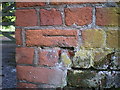
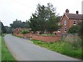
OS benchmark - Beckbury, Snowdon Farm barn
An OS cutmark on the rather weathered bricks at the corner of a barn (now converted to residences); originally levelled at 69.342m above Ordnance Datum Newlyn.
Image: © Richard Law
Taken: 22 May 2016
0.05 miles
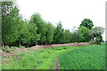
5
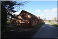
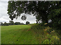
Snowdon Farm Path
The view off Snowdon Lane of the Bridleway near Beckbury.
Image: © Gordon Griffiths
Taken: 20 Aug 2010
0.09 miles
7
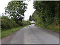
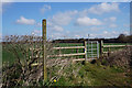
Snowdon Lane View
The lane from Burnhill Green to Beckbury.
Image: © Gordon Griffiths
Taken: 20 Aug 2010
0.11 miles
9
Field Boundary near Burnhill Green, Shropshire
The woodland is fairly immature here, and I presume the old straw etc. draped over the iron fence is added protection and cover for pheasant.
Image: © Roger Kidd
Taken: 17 May 2007
0.15 miles
10
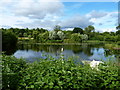
Pool at Lower Snowdon
This pool was excavated maybe 5 or 6 years ago, and at the time the surrounding fields looked like they'd never recover from the earthmoving. Not so - it now blends in very nicely, and has been planted about with small copses of native trees.
Image: © Richard Law
Taken: 9 Jul 2010
0.19 miles