IMAGES TAKEN NEAR TO
Marlbrook Lane, WOLVERHAMPTON, WV6 7BS
Introduction
This page details the photographs taken nearby to Marlbrook Lane, WV6 7BS by members of the Geograph project.
The Geograph project started in 2005 with the aim of publishing, organising and preserving representative images for every square kilometre of Great Britain, Ireland and the Isle of Man.

There are currently over 7.5m images from over14,400 individuals and you can help contribute to the project by visiting https://www.geograph.org.uk
Image Map
Images are licensed for reuse under creativecommons.org/licenses/by-sa/2.0
Notes
- Clicking on the map will re-center to the selected point.
- The higher the marker number, the further away the image location is from the centre of the postcode.
Image Listing (12 Images Found)
Images are licensed for reuse under creativecommons.org/licenses/by-sa/2.0
Image
Details
Distance
1
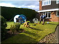
Scarecrow Camp
The view off Windsor Road in Pattingham part of the Scarecrow Festival.
Image: © Gordon Griffiths
Taken: 23 Sep 2017
0.14 miles
2
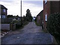
Broadwell Lane
The view down the lane off the High Street in Pattingham.
Image: © Gordon Griffiths
Taken: 6 Mar 2017
0.14 miles
3
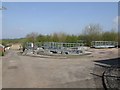
Sewage treatment works
Small treatment works on the outskirts of Pattingham village.
Image: © John M
Taken: 7 Apr 2007
0.16 miles
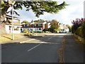
5
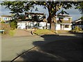
Houses on Hall End Lane
Modern 1970s houses on Hall End Lane near its junction with the High Street in Pattingham.
Image: © Philip Halling
Taken: 19 Oct 2016
0.18 miles
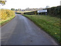
6
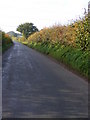
Rudge Road
The lane from Pattingham towards Rudge.
Image: © Gordon Griffiths
Taken: 30 Oct 2010
0.18 miles
7
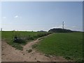
Footpath to Rudge Hall
The footpath is signed but is not shown on the OS mapping. It runs from Pattingham towards the hall.
Image: © John M
Taken: 7 Apr 2007
0.18 miles
8
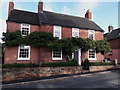
Bay House, Pattingham
Dated to 1833, this rather fine town house was Grade II listed, along with the dwarf walls and railings to the front https://britishlistedbuildings.co.uk/101188579-bay-house-with-dwarf-walls-railings-and-gate-to-front-garden-pattingham-and-patshull#.XbyjQuj7TIU & https://historicengland.org.uk/listing/the-list/list-entry/1188579 in 1985
Image: © Richard Law
Taken: 6 Oct 2019
0.20 miles
9
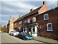
The Crown, Pattingham
The Crown public house on the High Street in Pattingham.
Image: © Philip Halling
Taken: 19 Oct 2016
0.22 miles
10
Pattingham Approach
The view on Rudge Road from Pattingham to the Bridgnorth Road.
Image: © Gordon Griffiths
Taken: 30 Oct 2010
0.23 miles