IMAGES TAKEN NEAR TO
Tettenhall Road, WOLVERHAMPTON, WV6 0JY
Introduction
This page details the photographs taken nearby to Tettenhall Road, WV6 0JY by members of the Geograph project.
The Geograph project started in 2005 with the aim of publishing, organising and preserving representative images for every square kilometre of Great Britain, Ireland and the Isle of Man.

There are currently over 7.5m images from over14,400 individuals and you can help contribute to the project by visiting https://www.geograph.org.uk
Image Map
Images are licensed for reuse under creativecommons.org/licenses/by-sa/2.0
Notes
- Clicking on the map will re-center to the selected point.
- The higher the marker number, the further away the image location is from the centre of the postcode.
Image Listing (176 Images Found)
Images are licensed for reuse under creativecommons.org/licenses/by-sa/2.0
Image
Details
Distance
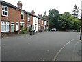
1
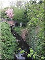
Smestow Brook at Newbridge
The brook passes under the A41 embankment in a large concrete pipe. The original blue brick culvert has been kept as an overflow channel.
Image: © John M
Taken: 21 Apr 2007
0.01 miles
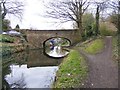
2
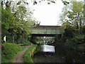
Tettenhall New Bridge, Bridge No 62
A 1960s bridge carries the A41 over the Staffs & Worcs Canal at Newbridge. The London to Holyhead Road was much improved as a turnpike in the 1820s by Thomas Telford. A new bridge was built over the canal to suit the raised and straightened alignment at the nearby Tettenhall Rock Cutting. The canal was built by James Brindley in 1776.
Image: © John M
Taken: 21 Apr 2007
0.02 miles
3
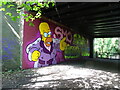
D'oh
The view of Homer Simpson painted on Tettenhall Road bridge in Wolverhampton, viewed from the former railway path.
Image: © Gordon Griffiths
Taken: 27 Jul 2023
0.02 miles
4
Old bridge at Newbridge
Built to carry the London - Holyhead road over the Staffs & Worcs Canal. When the road was improved by Thomas Telford in the early 1800s, the bridge was replaced by another, behind the original bridge in my photo. The area is now known as Newbridge because of this. Another medium format shot from my Agfa Isolette folding camera.
Image: © John Winder
Taken: 7 Dec 2014
0.02 miles
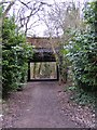
6
Tettenhall, old railway line
Section of the short-lived Dunstall Park to Brierley Hill railway, 1925-32. In the background, old Tettenhall Station, now the rangers' office. http://www.railaroundbirmingham.co.uk/Stations/tettenhall.php
Image: © Mike Faherty
Taken: 26 Apr 2009
0.02 miles
7

Tettenhall Old Bridge, Staffordshire & Worcestershire Canal
Image: © Ian S
Taken: 4 Sep 2021
0.02 miles
8
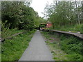
Railway Bridge
The view of the path on the Smestow Valley Local Nature Reserve near the former Tettenhall Railway Station.
Image: © Gordon Griffiths
Taken: 21 Feb 2018
0.02 miles
9
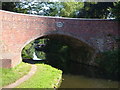
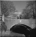
Tettenhall Old Bridge
Built 1770 across the Staffordshire & Worcestershire Canal, and superseded by the later bridge for the A41 a few yards further on. "By Brindley, Simcock and Dadford, engineers ... oval iron plaque to north with lettering: TETTENHALL/ OLD BRIDGE, AND NUMBER: 61. Bridge carried main Holyhead road until re-routed by T.Telford in 1820s " https://historicengland.org.uk/listing/the-list/list-entry/1201838 .
Image: © Derek Harper
Taken: 18 Jul 2006
0.02 miles
10
Old Bridge
The view of the Staffordshire and Worcestershire Canal at Tettenhall, Wolverhampton.
Image: © Gordon Griffiths
Taken: 21 Feb 2018
0.02 miles