IMAGES TAKEN NEAR TO
Gibbons Road, WOLVERHAMPTON, WV6 0JD
Introduction
This page details the photographs taken nearby to Gibbons Road, WV6 0JD by members of the Geograph project.
The Geograph project started in 2005 with the aim of publishing, organising and preserving representative images for every square kilometre of Great Britain, Ireland and the Isle of Man.

There are currently over 7.5m images from over14,400 individuals and you can help contribute to the project by visiting https://www.geograph.org.uk
Image Map
Images are licensed for reuse under creativecommons.org/licenses/by-sa/2.0
Notes
- Clicking on the map will re-center to the selected point.
- The higher the marker number, the further away the image location is from the centre of the postcode.
Image Listing (80 Images Found)
Images are licensed for reuse under creativecommons.org/licenses/by-sa/2.0
Image
Details
Distance
1
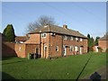
Housing - Gibbons Road
Three blocks face onto a central grassed area. The date is uncertain but it lies within an estate of 1923-4 properties built by the council and sold to private buyers in 1924.
Image: © John M
Taken: 12 Dec 2009
0.04 miles
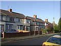
2
Council/Private Housing - Gibbons Road
Houses on the council built Newbridge Estate of 1923-4 were sold to meet a demand for private housing. The bay window may have been added as these were intended for private sale.
Image: © John M
Taken: 12 Dec 2009
0.07 miles
3
Council/Private Housing - Court Road
Houses on the Newbridge Estate built by the Council in 1923-4 were sold to meet a demand that could not be met at that time by private developers.
Image: © John M
Taken: 12 Dec 2009
0.08 miles
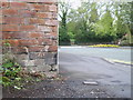
4
OS benchmark - Newbridge, Telephone Exchange building
OS cutmark located on the front of the BT building (which is still the local telephone exchange for the Tettenhall area) on Crowther Road; originally levelled at 111.825m above Ordnance Datum Newlyn.
Image: © Richard Law
Taken: 26 May 2016
0.10 miles
5
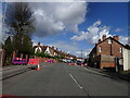
Newhampton Road West Lights
The view of the roadworks in Tettenhall, Wolverhampton.
Image: © Gordon Griffiths
Taken: 6 May 2021
0.12 miles
6
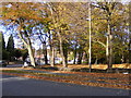
Tettenhall Road Junction
The view from New Hampton Road West in Wolverhampton.
Image: © Gordon Griffiths
Taken: 6 Nov 2016
0.14 miles
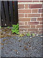
7
Benchmark - Newhampton Road
Benchmark cut into the brickwork of a wall at the western end of the Newhampton Road
Image: © Richard Law
Taken: 30 Apr 2010
0.14 miles
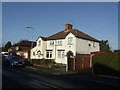
8
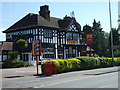
The Newbridge
A pub on the Tettenhall Road.
Image: © Gordon Griffiths
Taken: 30 Apr 2007
0.14 miles
9
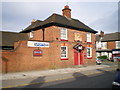
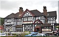
The Golden Eagle
A pub on the corner of Court Road and Hordern Road, between Aldersley and Whitmore Reans.
Image: © Richard Law
Taken: 13 May 2009
0.14 miles