IMAGES TAKEN NEAR TO
Rushwater Close, WOLVERHAMPTON, WV5 8JW
Introduction
This page details the photographs taken nearby to Rushwater Close, WV5 8JW by members of the Geograph project.
The Geograph project started in 2005 with the aim of publishing, organising and preserving representative images for every square kilometre of Great Britain, Ireland and the Isle of Man.

There are currently over 7.5m images from over14,400 individuals and you can help contribute to the project by visiting https://www.geograph.org.uk
Image Map
Images are licensed for reuse under creativecommons.org/licenses/by-sa/2.0
Notes
- Clicking on the map will re-center to the selected point.
- The higher the marker number, the further away the image location is from the centre of the postcode.
Image Listing (100 Images Found)
Images are licensed for reuse under creativecommons.org/licenses/by-sa/2.0
Image
Details
Distance
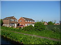
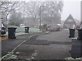
1
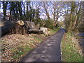
Millside, Wombourne
Fairly new housing development in Wombourne. Millside is a short cul-de-sac off Millfields Way, here viewed from the passing Staffordshire & Worcestershire Canal.
Image: © Bill Boaden
Taken: 22 Jun 2018
0.04 miles
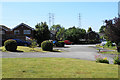
2
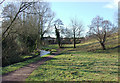
Marlburn Way
The view near the Wom Brook in Wombourne.
Image: © Gordon Griffiths
Taken: 9 Oct 2023
0.05 miles
3
Houses in Millside, Wombourne
On the west bank of the Staffs & Worcs Canal.
Image: © Christine Johnstone
Taken: 8 May 2018
0.05 miles
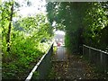
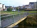
4
Bridge Scene
The view of the footbridge on the Wom Brook Walk at Giggetty, Wombourne.
Image: © Gordon Griffiths
Taken: 18 Jun 2020
0.05 miles
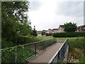
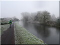
5
Forge Valley Way View
The misty view from the Wom Brook Walk in Giggetty, Wombourne.
Image: © Gordon Griffiths
Taken: 7 Jan 2021
0.06 miles
6
Foot Bridge Scene
The view of the bridge on the Wom Brook Walk at Giggetty, Wombourne.
Image: © Gordon Griffiths
Taken: 24 Jan 2018
0.06 miles
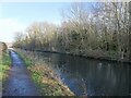
7
Misty Canal
The misty view north of the Bridgnorth Road on the Staffordshire and Worcestershire Canal at Wombourne.
Image: © Gordon Griffiths
Taken: 7 Jan 2021
0.06 miles
8
Frozen Canal
The view of the Staffordshire and Worcestershire Canal near Giggetty, Wombourne.
Image: © Gordon Griffiths
Taken: 23 Jan 2023
0.08 miles
9
Wom Brook Walk at Giggety, Wombourne, Staffordshire
The Wom Brook Walk is now a designated local nature reserve. http://en.wikipedia.org/wiki/Wom_Brook
http://www.keepbritaintidy.org/GreenFlag/GreenFlagAwardSites/WestMidlands/Default.aspx?parkID=979
Image: © Roger D Kidd
Taken: 29 Jan 2010
0.08 miles
10
Wom Walk Bench
The view along the Wom Brook Walk near Millfields Way at Giggetty, Wombourne.
Image: © Gordon Griffiths
Taken: 15 Mar 2018
0.08 miles