IMAGES TAKEN NEAR TO
Ludstone, Claverley, WOLVERHAMPTON, WV5 7DE
Introduction
This page details the photographs taken nearby to WV5 7DE by members of the Geograph project.
The Geograph project started in 2005 with the aim of publishing, organising and preserving representative images for every square kilometre of Great Britain, Ireland and the Isle of Man.

There are currently over 7.5m images from over14,400 individuals and you can help contribute to the project by visiting https://www.geograph.org.uk
Image Map
Images are licensed for reuse under creativecommons.org/licenses/by-sa/2.0
Notes
- Clicking on the map will re-center to the selected point.
- The higher the marker number, the further away the image location is from the centre of the postcode.
Image Listing (19 Images Found)
Images are licensed for reuse under creativecommons.org/licenses/by-sa/2.0
Image
Details
Distance
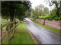
1
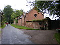
Ludstone Hall View
The view of the lane alongside Ludstone Hall near Claverley.
Image: © Gordon Griffiths
Taken: 18 Jun 2010
0.02 miles
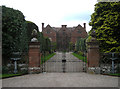
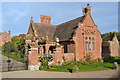
3
Ludstone Hall
Grade I listed moated Jacobean house built for the Whitmore family in 1607. The grounds and museum are opened one day per year for church funds.
Image: © John M
Taken: 13 Nov 2013
0.09 miles
4

Ludstone Hall
Ludstone Hall holds a Grade I listed status for its architectural and historical interest. It was built in the early 17th century (1607 or thereabouts) by the Whitmore family, and is still surrounded by the original moat, which isn't visible from this slightly low angle.
To be fair, most of the hall is in the next square to the east Image, but this western side lies in SO7994.
Image: © Richard Law
Taken: 31 Jan 2015
0.09 miles
5
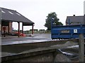
Good Name for a Trailer
The view of Ludstone Hall Farm near Claverley.
Image: © Gordon Griffiths
Taken: 18 Jun 2010
0.09 miles
6
Ludstone View
The view by Ludstone Hall near Claverley.
Image: © Gordon Griffiths
Taken: 18 Jun 2010
0.10 miles
7
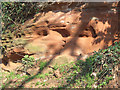
Sandstone Rock, Ludstone, Shropshire
The Triassic (Bunter) Sandstone can be seen in several places as the lane climbs the hill. Bunter does not refer to Billy. In German "bunter" means "brightly coloured. The Bunter Sandstone does contain extensive layers of colourful pebbles, and it is these that are the reason for the name.
Image: © Roger Kidd
Taken: 26 Mar 2007
0.11 miles
8
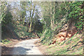
Narrow Lane from Ludstone, Shropshire
The lane climbs steeply up the ridge, cut deeply into, and exposing Triassic (Bunter) Sandstone in several places.
Image: © Roger Kidd
Taken: 26 Mar 2007
0.11 miles
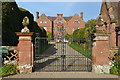
9
Lodge at Ludstone Hall
Grade II listed Gate Lodge c1850 with perimeter sandstone walls and gates.
Image: © John M
Taken: 13 Nov 2013
0.11 miles
10

Geese & ducks a'coming
A decent flock of mallards and Canadas, heading down the field towards Ludstone Lake.
Image: © Richard Law
Taken: 31 Jan 2015
0.12 miles