IMAGES TAKEN NEAR TO
Hopstone, Claverley, WOLVERHAMPTON, WV5 7BL
Introduction
This page details the photographs taken nearby to WV5 7BL by members of the Geograph project.
The Geograph project started in 2005 with the aim of publishing, organising and preserving representative images for every square kilometre of Great Britain, Ireland and the Isle of Man.

There are currently over 7.5m images from over14,400 individuals and you can help contribute to the project by visiting https://www.geograph.org.uk
Image Map
Images are licensed for reuse under creativecommons.org/licenses/by-sa/2.0
Notes
- Clicking on the map will re-center to the selected point.
- The higher the marker number, the further away the image location is from the centre of the postcode.
Image Listing (11 Images Found)
Images are licensed for reuse under creativecommons.org/licenses/by-sa/2.0
Image
Details
Distance
1
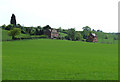
Cereal Crops and Farmhouse, Lower Hopstone, Shropshire
Image: © Roger Kidd
Taken: 30 Apr 2007
0.06 miles
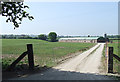
3
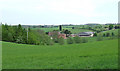
Fields North-East from Hopstone, Shropshire
The building complex is around Sutton Mill Farm
Image: © Roger Kidd
Taken: 30 Apr 2007
0.09 miles
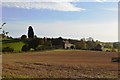
5
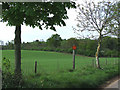
Fields and Woodland, Lower Hopstone, Shropshire
Neighbourhood Watch signs are prominently displayed in the region.
Image: © Roger Kidd
Taken: 26 Apr 2007
0.12 miles
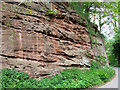
6
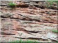
Bunter Sandstone, Hopstone, Shropshire
The height of the face shown is about 3 metres.
Image: © Roger Kidd
Taken: 30 Apr 2007
0.18 miles
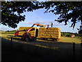
8
Poultry House, near Lower Hopstone, Shropshire
The hens roam around the field (and the track!) freely.
Image: © Roger Kidd
Taken: 3 May 2007
0.18 miles
9
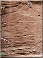
Bunter Sandstone (detail), Hopstone, Shropshire
Bunter is not a reference to Billy, but comes from the German word meaning "brightly coloured", because layers of coloured pebbles are often found in this Triassic rock. This image shows about one metre (height) of sandstone.
Image: © Roger Kidd
Taken: 30 Apr 2007
0.19 miles
10
Sandstone Exposure, Hopstone, Shropshire
The rock is exposed for about 100 metres on the western side of the lane. The height of the face here is about 4 metres (13 feet).
Image: © Roger Kidd
Taken: 30 Apr 2007
0.19 miles