IMAGES TAKEN NEAR TO
The Meadows, WOLVERHAMPTON, WV5 7AZ
Introduction
This page details the photographs taken nearby to The Meadows, WV5 7AZ by members of the Geograph project.
The Geograph project started in 2005 with the aim of publishing, organising and preserving representative images for every square kilometre of Great Britain, Ireland and the Isle of Man.

There are currently over 7.5m images from over14,400 individuals and you can help contribute to the project by visiting https://www.geograph.org.uk
Image Map
Images are licensed for reuse under creativecommons.org/licenses/by-sa/2.0
Notes
- Clicking on the map will re-center to the selected point.
- The higher the marker number, the further away the image location is from the centre of the postcode.
Image Listing (173 Images Found)
Images are licensed for reuse under creativecommons.org/licenses/by-sa/2.0
Image
Details
Distance
1
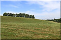
Pasture and trees west of Claverley, Shropshire
Looking north from the narrow lane to Chyknell Hall. There is a small isolated mobile homes "park" just over the brow of the hill past those trees.
Image: © Roger Kidd
Taken: 8 Sep 2021
0.05 miles
2
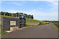
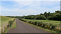
New road to All Saints Park, Claverley, Shropshire
It's behind those trees on the brow of the hill, quite a modest mobile homes "park" despite the rather pretentious announcement board here. Apparently it is aimed at the 45+ age group according to the agent's facebook page. https://www.facebook.com/769250213463058/posts/welcome-to-all-saints-park-this-exclusive-brand-new-residential-development-is-n/1153600468361362/
The road replaces a former farm track and public footpath. Streetview is still showing a 2009 image.
Image: © Roger Kidd
Taken: 8 Sep 2021
0.08 miles
3
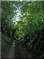
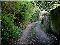
Digbeth Lane at Homelea near Claverley in Shropshire
Looking south-west near Homelea, towards the unsurfaced (byway) continuation of Digbeth Lane.
Image: © Roger Kidd
Taken: 8 Sep 2021
0.08 miles
4
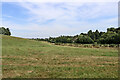
Pasture west of Claverley in Shropshire
Looking north-north-west from the narrow lane to Chyknell Hall. There was a farm track and public footpath at the edge of the field. Now it is a surfaced road.
Image: © Roger Kidd
Taken: 8 Sep 2021
0.08 miles
5
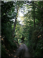
Digbeth Lane west of Claverley in Shropshire
Looking west-south-west near Homelea, towards the unsurfaced (byway) continuation of Digbeth Lane.
Image: © Roger Kidd
Taken: 8 Sep 2021
0.09 miles
6
New road west of Claverley in Shropshire
Looking north-north-west, the road replaces an earlier farm track and public footpath, and leads to a small mobile home "park" (off to the left and over the hill). The length of wall and sign board seem rather pretentious for such a "modest" development.
Streetview is still showing a 2009 image.
Image: © Roger Kidd
Taken: 8 Sep 2021
0.10 miles
7
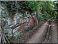
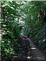
Sandstone exposure in Digbeth Lane near Claverley
Early Triassic red sandstone (Kidderminster Formation) formerly known as Bunter Pebble Beds.
This section of Digbeth Lane is a byway "open to all traffic", but becomes unsurfaced, and no more than a farm track further ahead towards Chyknell War Memorial.
Image: © Roger Kidd
Taken: 8 Sep 2021
0.10 miles
8
Digbeth Lane at Homelea near Claverley in Shropshire
Looking north-east near Homelea, west of Claverley.
Image: © Roger Kidd
Taken: 8 Sep 2021
0.11 miles
9
Digbeth Lane west of Claverley in Shropshire
Looking east near Homelea, west of Claverley.
Image: © Roger Kidd
Taken: 8 Sep 2021
0.11 miles
10
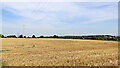
Farmland west of Claverley in Shropshire
Looking north-east across the stubble field from the narrow lane which leads towards Chyknell. Homelea Farm is on the left.
Image: © Roger Kidd
Taken: 8 Sep 2021
0.12 miles