IMAGES TAKEN NEAR TO
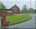
Kenilworth Crescent, WOLVERHAMPTON, WV4 6SQ
Introduction
This page details the photographs taken nearby to Kenilworth Crescent, WV4 6SQ by members of the Geograph project.
The Geograph project started in 2005 with the aim of publishing, organising and preserving representative images for every square kilometre of Great Britain, Ireland and the Isle of Man.

There are currently over 7.5m images from over14,400 individuals and you can help contribute to the project by visiting https://www.geograph.org.uk
Image Map
Images are licensed for reuse under creativecommons.org/licenses/by-sa/2.0
Notes
- Clicking on the map will re-center to the selected point.
- The higher the marker number, the further away the image location is from the centre of the postcode.
Image Listing (88 Images Found)
Images are licensed for reuse under creativecommons.org/licenses/by-sa/2.0
Image
Details
Distance
1
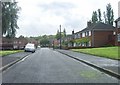
Kenilworth Crescent
The view in Parkfield, Wolverhampton.
Image: © Gordon Griffiths
Taken: 18 Jul 2012
0.02 miles
2

New roof on Kenilworth Crescent
Doesn't look like the builders will be done by the weekend...
Image: © Peter Whatley
Taken: 22 Oct 2008
0.04 miles
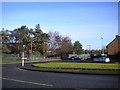
3
Wolverhampton Road East, Ettingshall Park
The service road on the right is accessible from Lawnswood Avenue at the north end and Dovedale Road at the south.
Image: © Richard Vince
Taken: 29 Dec 2013
0.04 miles
4
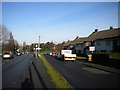
Wolverhampton Road East Bus Stop
The view from the service road alongside the A459.
Image: © Gordon Griffiths
Taken: 9 May 2012
0.05 miles

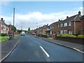
6
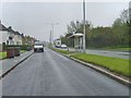
Wolverhampton Road East Crossing
The view up the A459 in Wolverhampton.
Image: © Gordon Griffiths
Taken: 1 Apr 2013
0.07 miles
7
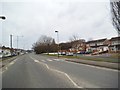
Lawnswood Avenue View
The Wolverhampton view towards Wolverhampton Road East.
Image: © Gordon Griffiths
Taken: 9 May 2012
0.07 miles
8
Bevan Avenue View
The view in Parkfields, Wolverhampton.
Image: © Gordon Griffiths
Taken: 18 Jul 2012
0.07 miles
9
Lawnswood Avenue View
The view from Kenilworth Crescent towards the South Wolverhampton and Bilston Academy, the former Parkfield High School.
Image: © Gordon Griffiths
Taken: 18 Jul 2012
0.07 miles
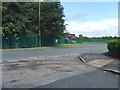
10
West end of Lawnswood Avenue, Ettingshall Park
Seen from Wolverhampton Road East.
Image: © Richard Vince
Taken: 29 Dec 2013
0.08 miles