IMAGES TAKEN NEAR TO
Ward Grove, WOLVERHAMPTON, WV4 6PH
Introduction
This page details the photographs taken nearby to Ward Grove, WV4 6PH by members of the Geograph project.
The Geograph project started in 2005 with the aim of publishing, organising and preserving representative images for every square kilometre of Great Britain, Ireland and the Isle of Man.

There are currently over 7.5m images from over14,400 individuals and you can help contribute to the project by visiting https://www.geograph.org.uk
Image Map
Images are licensed for reuse under creativecommons.org/licenses/by-sa/2.0
Notes
- Clicking on the map will re-center to the selected point.
- The higher the marker number, the further away the image location is from the centre of the postcode.
Image Listing (82 Images Found)
Images are licensed for reuse under creativecommons.org/licenses/by-sa/2.0
Image
Details
Distance
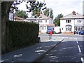
1
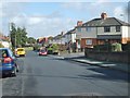
Ward Grove View
The view of the junction with Crawford Avenue on the Lanesfield Estate,Wolverhampton.
Image: © Gordon Griffiths
Taken: 17 Oct 2012
0.02 miles
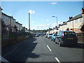
2
Pritchett Avenue Junction
The view of the junction with Ward Grove on the Lanesfield Estate,Wolverhampton.
Image: © Gordon Griffiths
Taken: 17 Oct 2012
0.03 miles
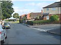
3
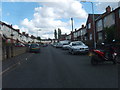
Pritchett Avenue
The view in Lanesfield, Wolverhampton.
Image: © Gordon Griffiths
Taken: 25 Jul 2012
0.04 miles
4
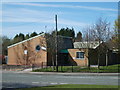
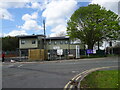
Lanesfield Youth Centre
This Community Centre stands on the corner of Ward Grove and the Birmingham New Road.
Image: © Gordon Griffiths
Taken: 4 Apr 2007
0.06 miles
5
Lanesfield Nursery
The new Pioneers Nursery will open in September 2023.
This stands on the former Community Centre site on the corner of Ward Grove and the Birmingham New Road in Wolverhampton. The view in April 2007 Image
Image: © Gordon Griffiths
Taken: 26 Apr 2023
0.07 miles
6
Crawford Avenue
The view in Lanesfield, Wolverhampton.
Image: © Gordon Griffiths
Taken: 25 Jul 2012
0.07 miles
7
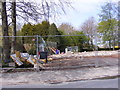
Ward Grove Building Site
The former Lanefield Community Centre site on the corner of Ward Grove and the Birmingham New Road. The view in 2007.Image
Image: © Gordon Griffiths
Taken: 3 May 2016
0.07 miles
8
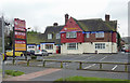
Indian Restaurant in Lanesfield, Wolverhampton
This is the Turmeric Indian Buffet Restaurant, recently re-opened following re-furbishment. It is doing its part towards the health of the nation with its "eat as much as you like" policy.
Until late last year it was The Copper Bowl buffet restaurant, serving Chinese, Thai and Indian dishes. Originally it was a public house called the Staffordshire Knot.
Image: © Roger D Kidd
Taken: 25 Feb 2013
0.08 miles
9
Gordon Avenue Box
The Post Box near the junction with Ward Grove.
Image: © Gordon Griffiths
Taken: 12 Jul 2009
0.08 miles
10
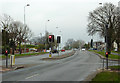
Birmingham New Road at Lanesfield, Wolverhampton
Looking towards Coseley.
This is the A4123 between Wolverhampton and Birmingham at the junction with Laburnum Road (off to the right). Birmingham New Road is one of those infuriating dual 40 mph carriageway roads with many junctions at which the traffic lights seem to turn red every time I approach them, even when nothing is waiting to enter from the side streets. :-(
Image: © Roger D Kidd
Taken: 25 Feb 2013
0.09 miles