IMAGES TAKEN NEAR TO
Parkfield Road, WOLVERHAMPTON, WV4 6EE
Introduction
This page details the photographs taken nearby to Parkfield Road, WV4 6EE by members of the Geograph project.
The Geograph project started in 2005 with the aim of publishing, organising and preserving representative images for every square kilometre of Great Britain, Ireland and the Isle of Man.

There are currently over 7.5m images from over14,400 individuals and you can help contribute to the project by visiting https://www.geograph.org.uk
Image Map
Images are licensed for reuse under creativecommons.org/licenses/by-sa/2.0
Notes
- Clicking on the map will re-center to the selected point.
- The higher the marker number, the further away the image location is from the centre of the postcode.
Image Listing (214 Images Found)
Images are licensed for reuse under creativecommons.org/licenses/by-sa/2.0
Image
Details
Distance
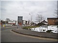
1
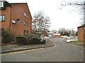
Parkfield Road Close
The view down to the A4039 in Parkfield, Wolverhampton.
Image: © Gordon Griffiths
Taken: 1 Apr 2013
0.02 miles
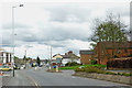
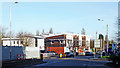
2
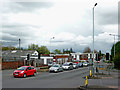
Parkfield Road in Wolverhampton
This is at the Fighting Cocks crossroads.
Parkfield Road is the A4039 between Penn and Bilston, and is seen looking east (towards Bilston) from the Aldi car park.
Image: © Roger Kidd
Taken: 20 Apr 2012
0.02 miles
3
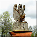
Phoenix sculpture in Parkfield Road, Wolverhampton
This fine carving is by the Phoenix Walk in and Health Centre in Parkfield Road (A4039) east of Fighting Cocks.
Image]
Image: © Roger Kidd
Taken: 20 Apr 2012
0.02 miles
4
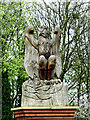
Phoenix sculpture in Parkfield Road, Wolverhampton
This fine carving is by the Phoenix Walk in and Health Centre in Parkfield Road (A4039) east of Fighting Cocks.
Image]
Image: © Roger Kidd
Taken: 20 Apr 2012
0.02 miles
5
Parkfields Road View
The view of the road next to the Phoenix Walk-in Health Centre in Parkfields Road Blakenhall, Wolverhampton.
Image: © Gordon Griffiths
Taken: 1 Apr 2013
0.02 miles
6
Parkfield Road in Wolverhampton
This is the A4039 Parkfield Road, looking east towards Bilston. The Phoenix Medical Centre is the white building on the left.
Image: © Roger Kidd
Taken: 20 Apr 2012
0.03 miles
7
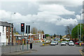
Parkfield Road in Wolverhampton
Looking east at the Fighting Cocks crossroads, the A4039 leads to Ettingshall and Bilston.
The A459 left leads to Wolverhampton City Centre, to the right - Sedgley and Dudley.
Image: © Roger Kidd
Taken: 20 Apr 2012
0.03 miles
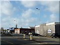
8
Parkfield Road at Fighting Cocks, Wolverhampton
This is at the crossroads known locally as Fighting Cocks, referring to the large public house which used to occupy the corner behind the camera (now an Aldi supermarket car park). Ahead is the A4039 Parkfields Road, leading towards Bilston.
Image: © Roger D Kidd
Taken: 31 Oct 2015
0.03 miles
9
Parkfield Road in Wolverhampton
Looking east towards Bilston, this is the A4039.
Behind the grey fence used to be the Brindley Volvo car show rooms, but they have been demolished, and a banqueting hall is being built! The large building ahead on the left is the Phoenix (walk-in) Health Centre, including an Urgent Treatment Centre (not 24 hour).
Image: © Roger Kidd
Taken: 20 Jan 2020
0.03 miles
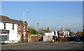
10
Former car showrooms, Wolverhampton
The Brindley Volvo car showrooms were here in Parkfield Road until about 2006(?). Since then the site has been disused.
Image: © Roger D Kidd
Taken: 30 Jan 2013
0.04 miles