IMAGES TAKEN NEAR TO
Wolverhampton Road East, WOLVERHAMPTON, WV4 6BD
Introduction
This page details the photographs taken nearby to Wolverhampton Road East, WV4 6BD by members of the Geograph project.
The Geograph project started in 2005 with the aim of publishing, organising and preserving representative images for every square kilometre of Great Britain, Ireland and the Isle of Man.

There are currently over 7.5m images from over14,400 individuals and you can help contribute to the project by visiting https://www.geograph.org.uk
Image Map
Images are licensed for reuse under creativecommons.org/licenses/by-sa/2.0
Notes
- Clicking on the map will re-center to the selected point.
- The higher the marker number, the further away the image location is from the centre of the postcode.
Image Listing (170 Images Found)
Images are licensed for reuse under creativecommons.org/licenses/by-sa/2.0
Image
Details
Distance
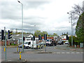
1
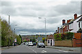
Wolverhampton Road East by Goldthorn Park
This is the A459 to Sedgley, Dudley and Halesowen, looking south-east from the Fighting Cocks crossroads.
Image: © Roger Kidd
Taken: 20 Apr 2012
0.01 miles
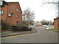
2
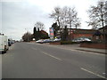
Wolverhampton Road East
The view down the A459 next to Goldthorn Park Estate, Wolverhampton.
Image: © Gordon Griffiths
Taken: 1 Apr 2013
0.02 miles
3
St John's
The view of the Methodist Church which opened in 1962 and stands on Wolverhampton Road East.
Image: © Gordon Griffiths
Taken: 1 Apr 2013
0.02 miles
4
St. John's Methodist Church
See http://www.wolvesmethodism.mikejackson.org.uk/St.%20John%27s/index.html
Image: © Mike Jackson
Taken: Unknown
0.04 miles
5
Parkfield Road Close
The view down to the A4039 in Parkfield, Wolverhampton.
Image: © Gordon Griffiths
Taken: 1 Apr 2013
0.06 miles
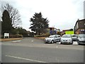
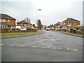
6
Fighting Cocks crossroads in Wolverhampton
This is the Fighting Cocks crossroads, looking east at the foot of Goldthorn Hill.
Ahead the A4039 to Bilston crosses the A459. The A459 to the left leads to Wolverhampton City Centre. To the right the A459 Wolverhampton Road East leads to Sedgley and Dudley.
Image: © Roger Kidd
Taken: 20 Apr 2012
0.07 miles
7
Longdon Avenue
The view on the Goldthorn Estate in Wolverhampton.
Image: © Gordon Griffiths
Taken: 20 Mar 2013
0.07 miles
8
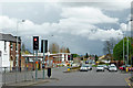
Parkfield Road in Wolverhampton
Looking east at the Fighting Cocks crossroads, the A4039 leads to Ettingshall and Bilston.
The A459 left leads to Wolverhampton City Centre, to the right - Sedgley and Dudley.
Image: © Roger Kidd
Taken: 20 Apr 2012
0.07 miles
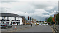
9

Aldi Parking
The view from the supermarket at Fighting Cocks on Goldthorn Hill, Wolverhampton.
Image: © Gordon Griffiths
Taken: 29 Jun 2019
0.08 miles
10
Parkfield Road in Wolverhampton
This is at the Fighting Cocks crossroads.
Parkfield Road is the A4039 between Penn and Bilston, and is seen looking east (towards Bilston) from the Wolverhampton Road East (A459).
Image: © Roger Kidd
Taken: 20 Apr 2012
0.08 miles