IMAGES TAKEN NEAR TO
Buller Street, WOLVERHAMPTON, WV4 6AH
Introduction
This page details the photographs taken nearby to Buller Street, WV4 6AH by members of the Geograph project.
The Geograph project started in 2005 with the aim of publishing, organising and preserving representative images for every square kilometre of Great Britain, Ireland and the Isle of Man.

There are currently over 7.5m images from over14,400 individuals and you can help contribute to the project by visiting https://www.geograph.org.uk
Image Map
Images are licensed for reuse under creativecommons.org/licenses/by-sa/2.0
Notes
- Clicking on the map will re-center to the selected point.
- The higher the marker number, the further away the image location is from the centre of the postcode.
Image Listing (175 Images Found)
Images are licensed for reuse under creativecommons.org/licenses/by-sa/2.0
Image
Details
Distance
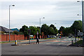
1
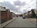
Buller Street View
The view down the Wolverhampton street.
Image: © Gordon Griffiths
Taken: 30 Apr 2013
0.03 miles
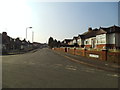
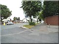
2
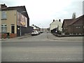
Buller Street
The view from Parkfield Road, Wolverhampton.
Image: © Gordon Griffiths
Taken: 1 Apr 2013
0.03 miles
3
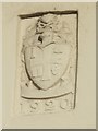
Coat of Arms - Parkfield Estate
The Parkfield Estate was among the first council housing built following the Great War. It marked the start of a major programme in the inter-war period. There are plaques on properties on Parkfield Road.Image] Image]
Image: © John M
Taken: 30 Oct 2010
0.04 miles
4
Olive Avenue
The view down the Avenue in Parkfield, Wolverhampton.
Image: © Gordon Griffiths
Taken: 30 Jul 2013
0.04 miles
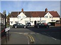
5

Birmingham New Road Junction
A Police Woman cycles into Parkfield Road, Wolverhampton.
Image: © Gordon Griffiths
Taken: 13 Jul 2009
0.05 miles
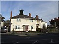
6
Birmingham New Road
This is the main route from Wolverhampton to Birmingham. Use it only if you have tons of patience. The road is filled with a seemingly unending string of traffic-lights all the way to Dudley where it deals with a congested roundabout then continues as the Wolverhampton New Road to Quinton where it meets the main road from Birmingham to J3 of the M5, passing several more sets of lights & M5 J2 on the way. If you have to travel between Wolverhampton & Birmingham park your car & go by train - its easier, quicker & ultimately cheaper.
Image: © Row17
Taken: 10 Jul 2009
0.06 miles
7
Greenly Road
The view of the junction with New Street in Parkfield, Wolverhampton.
Image: © Gordon Griffiths
Taken: 5 Mar 2013
0.06 miles
8
Council Housing - Parkfield Road
Early houses on the Parkfield Estate. The plaques have the council coat of arms dated 1920.
Image: © John M
Taken: 30 Oct 2010
0.07 miles
9
Council Housing - Parkfield Road/Thompson Avenue
Linked properties on the corner of Parkfield Road and Thompson Avenue. The date plaque and coat of arms shows the building was constructed in 1920. This marks the start of the major council house building programme which followed the Great War. The Parkfield Estate was built on the former Parkfield Colliery.
Image: © John M
Taken: 30 Oct 2010
0.07 miles
10
New Road View
The view from Dimmock Street junction with the A4126 Birmingham New Road at Parkfields, Wolverhampton.
Image: © Gordon Griffiths
Taken: 23 Jul 2013
0.07 miles