IMAGES TAKEN NEAR TO
Butts Road, WOLVERHAMPTON, WV4 5QD
Introduction
This page details the photographs taken nearby to Butts Road, WV4 5QD by members of the Geograph project.
The Geograph project started in 2005 with the aim of publishing, organising and preserving representative images for every square kilometre of Great Britain, Ireland and the Isle of Man.

There are currently over 7.5m images from over14,400 individuals and you can help contribute to the project by visiting https://www.geograph.org.uk
Image Map
Images are licensed for reuse under creativecommons.org/licenses/by-sa/2.0
Notes
- Clicking on the map will re-center to the selected point.
- The higher the marker number, the further away the image location is from the centre of the postcode.
Image Listing (373 Images Found)
Images are licensed for reuse under creativecommons.org/licenses/by-sa/2.0
Image
Details
Distance
1
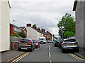
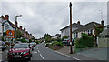
Butts Road in Penn, Wolverhampton
Butts Road is a cul-de-sac, seen here from Wakeley Hill by looking north-east towards Swan Bank (footpath link only).
Image: © Roger D Kidd
Taken: 14 Jul 2024
0.01 miles
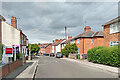
2
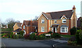
Modern Housing, Penn, Wolverhampton
These attractive, if rather densely built, houses were erected in the 1980s following the demolition and sale of Manor Road School (Colton Hills Lower School Annexe) and its playing fields.
Image: © Roger D Kidd
Taken: 1 Feb 2008
0.07 miles
3
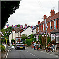
Wakeley Hill street party in Wolverhampton
Looking north-west towards Church Hill.
Preparations are being made for the afternoon's street party to commemorate Black Country Day, 14 July 2024.
Notices on telegraph poles were seen locally well in advance, but there was nothing on the internet to indicate the road would be closed, not even on the council website regarding street parties. The police arrived earlier, and even they had not been informed by the council that permission had been granted. There were no "road closed" or diversion signs either at the junction with Church Hill, or the junction with Mount Road (behind the camera).
Image: © Roger D Kidd
Taken: 14 Jul 2024
0.07 miles
4
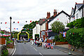
Wakeley Hill in Penn, Wolverhampton
Preparations are being made for a street party to commemorate Black Country Day, 14 July 2024.
Notices on telegraph poles were seen locally well in advance, but there was nothing on line to indicate the road would be closed, not even on the council website regarding street parties. The police arrived earlier, and even they had not been informed by the council that permission had been granted. There were no "road closed" or diversion signs either at the junction with Church Hill, or the junction with Mount Road.
Image: © Roger D Kidd
Taken: 14 Jul 2024
0.08 miles
5
Wakeley Hill in Penn, Wolverhampton
Looking south-east towards Colton Hills and Penn Common.
This was labelled as Wakeley Lane on late Victorian maps, and locally was also commonly called Workhouse Lane.
The housing on the right is on land worked as a garden from the workhouse, which old tithe maps show was about 85 metres ahead, on the right, and is now called Ivy Terrace.
Image: © Roger Kidd
Taken: 25 Sep 2021
0.08 miles
6
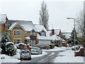
Attractive housing in Penn, Wolverhampton
Although they are rather close together, the houses on this estate (built in the 1980s on the former Colton Hills School Annexe site) are attractively varied in character. The late March snow was part of the coldest March since 1962.
Image: © Roger D Kidd
Taken: 24 Mar 2013
0.09 miles
7
Wakeley Hill in Penn, Wolverhampton
Looking north-west towards Church Hill.
Image: © Roger D Kidd
Taken: 14 Jul 2024
0.09 miles
8
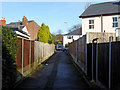
Footpath in Upper Penn, Wolverhampton
This public footpath leads between houses, linking Butts Road with Swan Bank, then continues through to Manor Road.
Image: © Roger Kidd
Taken: 20 Jan 2020
0.09 miles
9
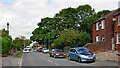
Swan Bank in Penn, Wolverhampton
Looking north towards Manor Road from near the junction with Wakeley Hill.
Image: © Roger Kidd
Taken: 21 Jul 2023
0.09 miles
10
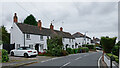
Ivy Terrace on Wakeley Hill, Wolverhampton
Looking west-north-west towards Church Hill and the A449 Penn Road.
Wakeley Hill is shown as Wakeley Lane on late Victoria Ordnance Survey maps. Housing is a hotch-potch of buildings with a few Victorian, and various early-mid-late twentieth century properties.
A notable exception is this terrace of three, which is Grade II listed, and dates from the late 18th or early 19th century. https://britishlistedbuildings.co.uk/101282463-ivy-terrace-penn-ward
The 1843 tithe map shows it (as plots 21/21A) to have been a workhouse with garden, which will explain why the road was also called Workhouse Lane locally (as in the 1881 census). The garden was a narrow long (about 132 yards; or six chains; or 120 metres) strip of land (with a pond) by the lane stretching from behind the camera, and past the terrace by seventy metres almost as far as Butts Road. It is now fully built over with housing.
The terrace is numbered 43-49 (odd) Wakeley Hill currently, though 47 and 49 have been knocked together internally as a single residence. Also, the small "extension" at the far end is separately lived in as No 43.
See also Image]
Image: © Roger Kidd
Taken: 25 Sep 2021
0.10 miles