Ivy Terrace on Wakeley Hill, Wolverhampton
Introduction
The photograph on this page of Ivy Terrace on Wakeley Hill, Wolverhampton by Roger Kidd as part of the Geograph project.
The Geograph project started in 2005 with the aim of publishing, organising and preserving representative images for every square kilometre of Great Britain, Ireland and the Isle of Man.

There are currently over 7.5m images from over 14,400 individuals and you can help contribute to the project by visiting https://www.geograph.org.uk
Ivy Terrace on Wakeley Hill, Wolverhampton
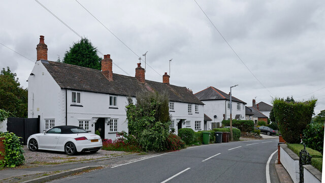
Image: © Roger Kidd Taken: 25 Sep 2021
Looking west-north-west towards Church Hill and the A449 Penn Road. Wakeley Hill is shown as Wakeley Lane on late Victoria Ordnance Survey maps. Housing is a hotch-potch of buildings with a few Victorian, and various early-mid-late twentieth century properties. A notable exception is this terrace of three, which is Grade II listed, and dates from the late 18th or early 19th century. https://britishlistedbuildings.co.uk/101282463-ivy-terrace-penn-ward The 1843 tithe map shows it (as plots 21/21A) to have been a workhouse with garden, which will explain why the road was also called Workhouse Lane locally (as in the 1881 census). The garden was a narrow long (about 132 yards; or six chains; or 120 metres) strip of land (with a pond) by the lane stretching from behind the camera, and past the terrace by seventy metres almost as far as Butts Road. It is now fully built over with housing. The terrace is numbered 43-49 (odd) Wakeley Hill currently, though 47 and 49 have been knocked together internally as a single residence. Also, the small "extension" at the far end is separately lived in as No 43. See also Image]
Images are licensed for reuse under creativecommons.org/licenses/by-sa/2.0
Image Location
Latitude
52.55697
Longitude
-2.152765