IMAGES TAKEN NEAR TO
Church Hill, WOLVERHAMPTON, WV4 5PN
Introduction
This page details the photographs taken nearby to Church Hill, WV4 5PN by members of the Geograph project.
The Geograph project started in 2005 with the aim of publishing, organising and preserving representative images for every square kilometre of Great Britain, Ireland and the Isle of Man.

There are currently over 7.5m images from over14,400 individuals and you can help contribute to the project by visiting https://www.geograph.org.uk
Image Map
Images are licensed for reuse under creativecommons.org/licenses/by-sa/2.0
Notes
- Clicking on the map will re-center to the selected point.
- The higher the marker number, the further away the image location is from the centre of the postcode.
Image Listing (194 Images Found)
Images are licensed for reuse under creativecommons.org/licenses/by-sa/2.0
Image
Details
Distance
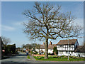
1
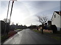
Church Hill View
The view towards St. Bartholomew's Church in Penn, Wolverhampton.
Image: © Gordon Griffiths
Taken: 18 Jan 2021
0.01 miles
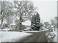
2
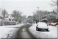
Church Hill in Penn, Wolverhampton
Church Hill is seen here, looking south towards Penn Common from near the junction with Wakeley Hill.
Image: © Roger D Kidd
Taken: 10 Dec 2017
0.03 miles
3
Church Hill in Penn, Wolverhampton
Church Hill is seen here, looking north towards the A449 Penn Road from near the junction with Wakeley Hill.
Image: © Roger D Kidd
Taken: 10 Dec 2017
0.03 miles
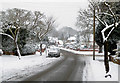
4
Church Hill in Penn, Wolverhampton
Church Hill is seen here, looking south towards Penn Common from near the junction with Brenton Road.
Image: © Roger D Kidd
Taken: 10 Dec 2017
0.03 miles
5
Church Hill in Penn, Wolverhampton
Church Hill leads from Penn Village (the A449) to St Bartholomew's Church on Penn Common. Wakeley Hill leads off to the left, towards Colton Hills and Penn Golf Club.
Image: © Roger D Kidd
Taken: 10 Dec 2017
0.04 miles
6
Church Hill and Wakeley Hill in Penn, Wolverhampton
Church Hill leads from Penn Village (the A449) to St Bartholomew's Church on Penn Common. Wakeley Hill leads off to the left, towards Colton Hills and Penn Golf Club.
In Victorian times this was Wakeley Lane (not Hill), was often called Workhouse Lane. Old tithe maps show the workhouse about three hundred metres up the hill, on the right, rather than in cottages off to the left, which has been suggested.
Image: © Roger D Kidd
Taken: 10 Dec 2017
0.04 miles

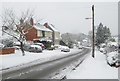
8
Brenton Road in Penn, Wolverhampton
Looking south-east towards Wakeley Hill from the junction with Church Hill.
Image: © Roger D Kidd
Taken: 10 Dec 2017
0.05 miles
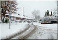
9
Church Hill in Penn, Wolverhampton
This is looking down Church Hill at the junction with Wakeley Hill.
Image: © Roger D Kidd
Taken: 29 Mar 2012
0.05 miles
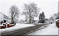
10
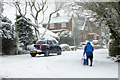
Lea Manor Drive in Penn, Wolverhampton
This cul-de-sac is seen here from the junction with Church Hill. About 15-18cm of snow was covering open ground after falls on two consecutive days.
Image: © Roger D Kidd
Taken: 10 Dec 2017
0.05 miles