IMAGES TAKEN NEAR TO
Buttons Farm Road, WOLVERHAMPTON, WV4 5LY
Introduction
This page details the photographs taken nearby to Buttons Farm Road, WV4 5LY by members of the Geograph project.
The Geograph project started in 2005 with the aim of publishing, organising and preserving representative images for every square kilometre of Great Britain, Ireland and the Isle of Man.

There are currently over 7.5m images from over14,400 individuals and you can help contribute to the project by visiting https://www.geograph.org.uk
Image Map
Images are licensed for reuse under creativecommons.org/licenses/by-sa/2.0
Notes
- Clicking on the map will re-center to the selected point.
- The higher the marker number, the further away the image location is from the centre of the postcode.
Image Listing (92 Images Found)
Images are licensed for reuse under creativecommons.org/licenses/by-sa/2.0
Image
Details
Distance
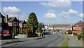
1
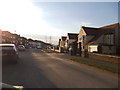
Buttons Farm Road
The view in Penn, Wolverhampton.
Image: © Gordon Griffiths
Taken: 30 Mar 2013
0.03 miles
2
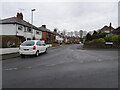
Holden Road
The view from Buttons Farm Road, Penn.
Image: © Gordon Griffiths
Taken: 22 Dec 2020
0.04 miles
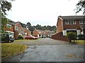
3
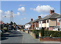
Holden Road, Spring Hill, Wolverhampton
Semi-detached housing, looking towards Buttons Farm Road.
Image: © Roger D Kidd
Taken: 9 Mar 2010
0.04 miles
4
Buttons Farm Road View
The view in Penn, Wolverhampton.
Image: © Gordon Griffiths
Taken: 22 Dec 2020
0.05 miles
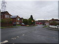
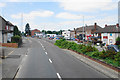
5
Buttons Farm Road, Spring Hill, Wolverhampton
This is looking north-west from the junction with Holden Road, towards the dual carriageway Penn Road/Stourbridge Road (A449).
Image: © Roger D Kidd
Taken: 9 Mar 2010
0.06 miles
6
Foxlands Drive Close
The view from Foxlands Drive in Spring Hill, Penn, Staffordshire near the Wolverhampton border.
Image: © Gordon Griffiths
Taken: 14 Aug 2015
0.08 miles
7
Foxlands Drive Scene
The view down the A449 from Foxlands Drive in Spring Hill, Penn, Staffordshire near the Wolverhampton border.
Image: © Gordon Griffiths
Taken: 14 Aug 2015
0.09 miles
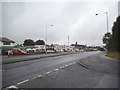
8

Penn Road
The view from Springhill Lane in Spring Hill, Wolverhampton.
Image: © Gordon Griffiths
Taken: 5 Feb 2021
0.09 miles
9
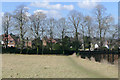
Field and footpath by Penn Cemetery, Wolverhampton
It is worth taking a look at the Google satellite image. The landscaping has surely been done with the idea that this field will eventually become part of the cemetery. The public footpath by the cemetery fence goes into Holden Road through kissing gates at the end of the fence.
Image: © Roger D Kidd
Taken: 9 Mar 2010
0.09 miles
10
Penn Road
A row of shops at Spring Hill.
Image: © Bill Boaden
Taken: 22 Jun 2018
0.09 miles