IMAGES TAKEN NEAR TO
Buttons Farm Road, WOLVERHAMPTON, WV4 5LR
Introduction
This page details the photographs taken nearby to Buttons Farm Road, WV4 5LR by members of the Geograph project.
The Geograph project started in 2005 with the aim of publishing, organising and preserving representative images for every square kilometre of Great Britain, Ireland and the Isle of Man.

There are currently over 7.5m images from over14,400 individuals and you can help contribute to the project by visiting https://www.geograph.org.uk
Image Map
Images are licensed for reuse under creativecommons.org/licenses/by-sa/2.0
Notes
- Clicking on the map will re-center to the selected point.
- The higher the marker number, the further away the image location is from the centre of the postcode.
Image Listing (81 Images Found)
Images are licensed for reuse under creativecommons.org/licenses/by-sa/2.0
Image
Details
Distance
1
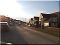
Buttons Farm Road
The view in Penn, Wolverhampton.
Image: © Gordon Griffiths
Taken: 30 Mar 2013
0.03 miles
2
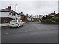
Holden Road
The view from Buttons Farm Road, Penn.
Image: © Gordon Griffiths
Taken: 22 Dec 2020
0.04 miles
3
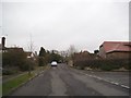
Buttons Farm Road End
The view from Hartill Road junction in Penn, Wolverhampton.
Image: © Gordon Griffiths
Taken: 1 Dec 2014
0.05 miles
4
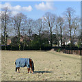
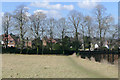
Grazing near Spring Hill, Wolverhampton
This field adjacent to Penn Cemetery shows no signs of new grass growth. Frequent night frosts persisted through into mid-March at the end of the coldest winter in England for over thirty years. The public footpath by the cemetery fence on the right leads into Holden Road. The houses on the right are in Penn Road.
Image: © Roger D Kidd
Taken: 9 Mar 2010
0.06 miles
5
Field and footpath by Penn Cemetery, Wolverhampton
It is worth taking a look at the Google satellite image. The landscaping has surely been done with the idea that this field will eventually become part of the cemetery. The public footpath by the cemetery fence goes into Holden Road through kissing gates at the end of the fence.
Image: © Roger D Kidd
Taken: 9 Mar 2010
0.06 miles
6
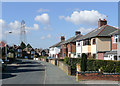
Holden Road, Spring Hill, Wolverhampton
Semi-detached housing, looking towards Buttons Farm Road.
Image: © Roger D Kidd
Taken: 9 Mar 2010
0.06 miles
7
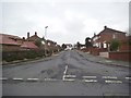
Hartill Road
The view in Penn, Wolverhampton.
Image: © Gordon Griffiths
Taken: 1 Dec 2014
0.06 miles
8
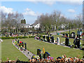
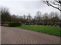
Penn Cemetery, Spring Hill, Wolverhampton
This very well maintained cemetery is a council operated facility. Housing in Penn Road (A449) is in the distance. Housing on the Penn Road (A49) is in the background.
This information is given on their website:
"Penn Cemetery was opened in 1993 as a community cemetery, providing approximately 6.5 acres of lawn style graves. The memorial regulations allow for greater freedom of choice for the bereaved, in the size, height and style of the memorials permitted. There are no new full burial graves available at this cemetery however, spare capacity is available for cremated remains and babies graves."
Image: © Roger D Kidd
Taken: 9 Mar 2010
0.08 miles
9
Penn Cemetery
The view of the cemetery alongside the Penn Road in Wolverhampton.
Image: © Gordon Griffiths
Taken: 1 Mar 2021
0.08 miles
10
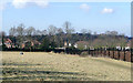
Field by Penn Cemetery, Wolverhampton
Following an extended cold winter, there is still no new grass growth for the horses grazing. It is worth taking a look at the Google satellite image. The landscaping has surely been done with the idea that this field will eventually become part of the cemetery. The public footpath by the cemetery fence goes into Holden Road through kissing gates at the end of the fence.
Image: © Roger D Kidd
Taken: 9 Mar 2010
0.09 miles