IMAGES TAKEN NEAR TO
Fareham Crescent, WOLVERHAMPTON, WV4 4YQ
Introduction
This page details the photographs taken nearby to Fareham Crescent, WV4 4YQ by members of the Geograph project.
The Geograph project started in 2005 with the aim of publishing, organising and preserving representative images for every square kilometre of Great Britain, Ireland and the Isle of Man.

There are currently over 7.5m images from over14,400 individuals and you can help contribute to the project by visiting https://www.geograph.org.uk
Image Map
Images are licensed for reuse under creativecommons.org/licenses/by-sa/2.0
Notes
- Clicking on the map will re-center to the selected point.
- The higher the marker number, the further away the image location is from the centre of the postcode.
Image Listing (45 Images Found)
Images are licensed for reuse under creativecommons.org/licenses/by-sa/2.0
Image
Details
Distance
1
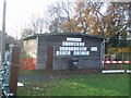
Scout hut and playschool
The 1st Finchfield Scouts share this building in Merry Hill with a playschool.
Image: © John M
Taken: 2 Dec 2006
0.01 miles
2
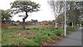
Site of Merry Hill Centre and Merry Hill House
Merry Hill House (a careor nursing home) and Merry Hill Centre (a community centre) stood on this site, but have been demolished in the past year or so.
Image: © Paul Collins
Taken: 21 Oct 2017
0.04 miles
3
The Merry Hill
Large public house next to roundabout and busy local centre in Merry Hill.
Image: © John M
Taken: 2 Dec 2006
0.07 miles
4
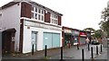
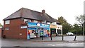
Former Halifax Branch and Shops at Five Ways, Merry Hill
These units form part of a local shopping centre located around an attractively planted roundabout. There is the usual selection of businesses, mainly comprising charity and betting shops, convenience stores and food establishments.
Image: © Paul Collins
Taken: 21 Oct 2017
0.08 miles
5
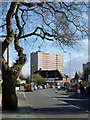
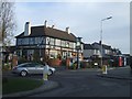
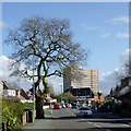
Bhylls Lane in Merry Hill, Wolverhampton
Looking towards the junction with Langley Road. The tower block is St Joseph's Court. There are two more similar blocks nearby to the right.
Image: © Roger D Kidd
Taken: 4 Mar 2015
0.09 miles
6
Shopping Parade at Five Ways, Merry Hill
Image: © Paul Collins
Taken: 21 Oct 2017
0.09 miles
7
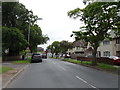
Five Ways View
The view from Finchfield Lane, Wolverhampton.
Image: © Gordon Griffiths
Taken: 13 Jul 2019
0.10 miles
8
Bhylls Lane in Merry Hill, Wolverhampton
Looking towards the junction with Langley Road. The tower block is St Joseph's Court. There are two more similar blocks nearby to the right.
Image: © Roger D Kidd
Taken: 4 Mar 2015
0.10 miles
9
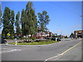
Five Ways, Merry Hill
This roundabout, the focal point of Merry Hill district centre, was used for turning by Wolverhampton Corporation's Merry Hill trolleybus route, latterly numbered 13 and operating from Low Hill (Pear Tree) via the town centre. The trolleybuses arrived via Trysull Road (on the right, flanked by bus shelters); the main bus service here still arrives that way, but nowadays it continues to Springhill.
Image: © Richard Vince
Taken: 6 Jun 2013
0.10 miles
10
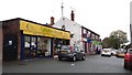
Shops at Five Ways, Merry Hill
These units form part of a local shopping centre located around a roundabout. There is the usual selection mainly comprising charity and betting shops, convenience stores and food establishments.
Image: © Paul Collins
Taken: 21 Oct 2017
0.10 miles