IMAGES TAKEN NEAR TO
Claverley Drive, WOLVERHAMPTON, WV4 4QW
Introduction
This page details the photographs taken nearby to Claverley Drive, WV4 4QW by members of the Geograph project.
The Geograph project started in 2005 with the aim of publishing, organising and preserving representative images for every square kilometre of Great Britain, Ireland and the Isle of Man.

There are currently over 7.5m images from over14,400 individuals and you can help contribute to the project by visiting https://www.geograph.org.uk
Image Map
Images are licensed for reuse under creativecommons.org/licenses/by-sa/2.0
Notes
- Clicking on the map will re-center to the selected point.
- The higher the marker number, the further away the image location is from the centre of the postcode.
Image Listing (25 Images Found)
Images are licensed for reuse under creativecommons.org/licenses/by-sa/2.0
Image
Details
Distance
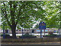
1
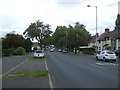
Warstones Road, Wolverhampton
Towards Merry Hill.
Image: © JThomas
Taken: 22 Aug 2019
0.08 miles
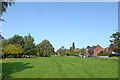
2
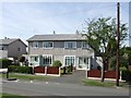
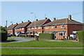
Council Housing - Claverley Drive
The immediate post war period saw some inovative designs using preformed components such as these houses on the Warstones Estate.
Image: © John M
Taken: 9 Apr 2011
0.08 miles
3
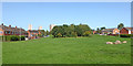
Warstones Green near Penn in Wolverhampton
Looking north towards Merry Hill from near Swancote Drive.
Image: © Roger Kidd
Taken: 17 Sep 2020
0.11 miles
4
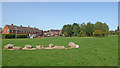
Warstones Green near Penn in Wolverhampton
Looking north-west towards housing in North Green. I wonder if the younger children call their only play equipment "the war stones" and have mock battles!
Image: © Roger Kidd
Taken: 17 Sep 2020
0.11 miles
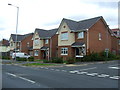
5
Springdale School
This Infant School stands on Warstones Drive.
Image: © Gordon Griffiths
Taken: 6 May 2007
0.11 miles
6
Warstones Green west of Penn in Wolverhampton
Looking north towards Merry Hill. Housing in East Green is on the right.
Image: © Roger Kidd
Taken: 17 Sep 2020
0.13 miles
8
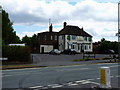
The Warstones
A public house on Warstones Road.
Image: © Richard Law
Taken: 5 Jul 2010
0.13 miles
9
Swancote Drive in Warstones, Wolverhampton
Looking west towards Highfields School, from Warstones Green.
Image: © Roger Kidd
Taken: 17 Sep 2020
0.15 miles
10
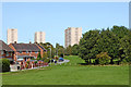
Warstones Green near Penn in Wolverhampton
Looking north towards the three tower blocks in Merry Hill. From left to right are Highfields Court, St Joseph's Court and Pennwood Court. Houses on the left are in North Green.
Image: © Roger Kidd
Taken: 17 Sep 2020
0.15 miles